Our neighborhood has many miles of local trails. Some were built and are maintained by our HOA Master Association, and therefore are private for residents only, and some are our county's open space parks available to all.
This is a beautiful world, and all who go out under the open sky will feel the gentle, kindly influence of nature and hear her good tidings." ~ Enos Mills

Some of the trails are concrete, some are gravel, and others are dirt. Many are utilized by hikers, bicycle riders, and horseback riders. I am not the fastest hiker going uphill, but slowly and surely, I manage. Taking photos helps me get a bit of rest before I go on.
"For how many years did I wander slowly...what wonders and glory I could have missed had I ever been in a hurry! ~ Mary Oliver

" Keep close to Nature's heart...
and break clear away, once in a while, and climb a mountain or spend a week in the woods. Wash your spirit clean."
~ Johm Muir

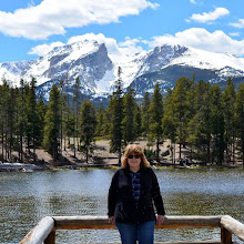
The trails pass red rock formations and meadows, and some gain a thousand feet of elevation beyond our area's average 6,000 feet (1828 Meters) elevation.

Over the years, my husband and I have walked the trails alone, with each other, our children, and with friends.
"The battle for conservation will go on endlessly. It is part of the universal battle between right and wrong."
~John Muir

I have photographed hundreds of wildflowers along the trails...these were just a few!
"I hope you are blessed with a heart like a wildflower
Strong enough to rise again after being trampled upon. tough enough to weather the worst of summer storms, and able to grow and flourish, even in the most broken places."
~ Nikita Gill

We have walked in all kinds of weather and all the seasons...in spring and summer...

...in Autumn...

...and in winter.
"To the attentive eye, each moment of the year has its own beauty, and in the same field, it beholds, every hour, a picture which was never seen before, and which shall never be seen again."
~ Ralph Waldo Emerson

“In every walk with nature one receives far more than he seeks.”
~ John Muir

On days we can't walk, and sadly, that has been many days because of high summer heat and poor air quality due to wildfires in our state this summer, my husband and I go to our nearby community gym.
It's small, but it is usually not crowded, and it has enough machines to choose from to do an hour workout. I like that the gym bicycles can be programmed to show rides through different national parks and scenic rides all around the world!

Even the twin fawns that were born in our backyard in June have been feeling this summer's excessive heat. They have been seeking out the shade of our trees for coolness. It has been fun watching them grow!
Where do you like to walk where you live?
How has the weather been where you live this season?
I can also be found on
Blogs I link with:
Nature Notes, Home Matters Linky Party, Happiness is Homemade, Monday Morning Blog Club, Senior Salon Pit Stop, Talk About It Tuesday, The Happy Now Tuesday, Happy Tuesday, Wordless Wednesday 2, Wordless Wednesday on Comedy Plus, Wonderful Wednesday, Thankful Thursday, Weekend Traffic Jam Report, Thursday Favorite Things, Skywatch Friday, Weekly Wisdoms, Fantastic Friday, Farmhouse Friday, Crazy Little Lovebirds Friday Link Up, Dare to Share, Saturday Sparks, Saturday Critters, Weekend Reflections