Sunday, June 8, 2025

North Park Colorado and the Arapaho National Wildlife Refuge


Last week, I blogged about our drive west from the Fort Collins, Colorado area along the Cache la Poudre River Scenic Byway into North Park--click here to read that post.
North Park is a high, sparsely populated basin (approximately 8,800 feet (2,700 m) in elevation) in the Rocky Mountains in north central Colorado
It is an expansive valley that stretches from north-central Colorado into Wyoming. Weighing in at more than a million acres that are 65% public land, North Park’s lakes, rivers, and wetlands draw all manner of wildlife, and the area features some of the most remote and sparsely populated wilderness terrains in the state.


North Park is comprised of a vast basin that’s fed by the North Platte, Michigan, Illinois, and Canadian Rivers, and is flanked by the Park Range to the west, the Medicine Bow Mountains, and the Never Summer Mountains to the east.


With over 71,000 acres to explore, State Forest State Park offers a diverse landscape of forest, majestic peaks, and alpine lakes, all brimming with wildlife. Stretching from the western slope of the Medicine Bow Mountains to the northern end of the Never Summer Mountain Range, the park offers year-round activities such as snowmobiling, geocaching, birding, hunting, horseback riding, and many more in one of the most stunning natural settings in the state.


“Moose is our claim to fame,” reads a line from State Forest State Park’s website. North Park is hailed as the Moose Viewing Capital of Colorado. The site goes on to say that an average of 600 moose are observed in North Park annually. 
We did not see any moose during our drive, but we were still excited about the female moose and her yearling calf we viewed in Rocky Mountain National Park the day before--click here-- to read that post.


As we drove along ....


...we soon passed by the small town of Walden.


There were also many cattle ranches in this area.


South of Walden, we stopped at an overlook for the Arapaho National Wildlife Refuge. The refuge sits at elevations as high as 8,700 feet, making it the highest animal refuge in the National Wildlife Refuge System in the continental US. The refuge’s habitats, which include irrigated meadows, riparian, sagebrush uplands, wetlands, and mixed conifer and aspen forests, host an abundance of diverse wildlife species.


The overlook view was magnificent!


The winding blue Illinois River fills the Arapaho National Wildlife Refuge, traveling through sagebrush and native grasses.


Please click on the photo to enlarge it to read the information on the placard.

The refuge was established in 1967 to furnish waterfowl with a suitable place to nest and rear their young. It was created in part to offset losses of nesting habitat in the prairie wetland region of the Midwest.


Please click on the photo above to read this refuge exhibit, one of many placards on site, to read how the North Park basin was formed 45 million years ago! 


The top wall of the overlook also had many informational plaques to read.


Please click to enlarge the photo.

The refuge is also home to elk, beaver, pronghorn, and porcupine.
To protect the fragile wildlife habitats it hosts, the refuge consistently closes much of the area to visitors, but a 6-mile self-guided auto route is open for year-round visitor activities and stunning scenic overlooks. We wished we had time to explore more, but vowed to return one day to see more of the refuge and North Park.


We loved seeing North Park and its natural ruggedness.

As we drove home, we passed the town of Granby and saw the headwaters of the Colorado River, and also sadly, the remains of the 2020 East Troublesome Wildfirethe second-largest wildfire in the history of Colorado.


Next, we passed through the ski town of Winter Parkwhere the slopes were still full of snow during our trip at the end of April.


We could have driven an hour home directly from Fort Collins, but taking the Cache La Poudre to North Park Scenic Byway-- Highway 14--was well worth the extra three-hour drive, as we passed through so many wonderful sights. 
I hope you enjoyed seeing them in my blog posts over the past few weeks!


Sunday, June 1, 2025

The Cache la Poudre and North Park Scenic Byway in Colorado, Part One


 Colorado has designated 26 areas as official scenic byways, with just over a dozen federally classified as American Byways. My husband and I have traveled many of them since moving to Colorado twelve years ago. While on a visit to Fort Collins- click here--to read that blog post, we learned there was a scenic drive nearby we could take as a detour side trip on our way back home.

The 101-mile corridor of Highway 14 between the city of Fort Collins and Walden, Colorado, constitutes the Cache la Poudre-North Park Scenic Byway. For much of the journey, the road parallels the Cache la Poudre River, Colorado’s only federally-designated National Wild and Scenic River. The river’s name translates from French to “hide the powder.” Legend tells that the river (pronounced "poo-der") was where French fur trappers decided to bury their gunpowder for retrieval in spring to lighten their load while traveling during a snowstorm in the mid-1800s. The name Caché la Poudre in French means ‘where the powder was hidden,’ and thus the river was named.


Along the drive, the rocky canyon twists and turns, crossing the river in a few places. The lower altitudes feature places where locals gather to engage in inner-tube rides and swimmers paddle in the slower-moving shallows. Rougher water can be found upriver, where rafters and kayakers challenge upwards of Class III rapids from May until late September.


As we drove through steep canyons, we saw hikers, fishermen, and campers along the way.


We enjoyed the wild, rustic scenery we saw along this part of the river!

A short video above of rapids on the Cache la Poudre River.

It was easy to see how the Rocky Mountains got their name!


As we gained elevation, we saw beautiful forest areas...


...but we also saw some areas that had been sadly devastated by past wildfires.


We stopped at the summit of Cameron Pass  (elevation 10,276 ft; 3,132 m). The pass is a gap between the south end of the Medicine Bow Mountains and the north end of the Never Summer Mountains


After descending from Cameron Pass, we entered a high plain area called North Park.


North Park is a high, sparsely populated basin (approximately 8,800 feet (2,700 m) in elevation). The valley receives its name from being the northernmost of the three large mountain valleys (or parks) in Colorado on the western side of the Front Range. The others are Middle Park and South Park respectively.  The basin opens northward into Wyoming, in the direction of flow of the North Platte. On the east side, it is rimmed by the Medicine Bow Mountains, the Never Summer Mountains, and Rabbit Ears Range to the south, and the Park Range to the west. The Continental Divide rims the Park along the south and west.

I find these high-elevation "parks" so mesmerizing! We live closest to South Park, and I've often blogged about it.

I have more to show about North Park and a wonderful wildlife refuge in Part Two of my next blog post--see you then!


Sunday, May 25, 2025

Cherry Pie along The Big Thompson River Canyom


In last week's blog post-- click here-- I showed our drive west from Loveland, Colorado, to Estes Park and into Rocky Mountain National Park along Highway 34, and the Big Thompson River Canyon route. Afterward, we returned on Highway 34 to drive east back to Loveland and then Fort Collins, where we stayed for a few days at the end of April.

As you can see, we had blue skies for part of the drive...


...but soon hit fog as we climbed in elevation.


The foggy views were beautiful and atmospheric. 


We noticed two memorial plaques at a pull-off and stopped to read them. The first was a memorial to two law enforcement officers, Colorado State Patrol Sgt. W. Hugh Purdy and Estes Park Patrol Michel O. Conley. They both died trying to save lives on July 31, 1976 when more than 140 people perished during a flash flood of Big Thompson Canyon


The second plaque was a memorial to Scott Ellis, 55, of Johnstown, Colorado, an experienced mountain biker who died while participating in the grueling Leadville, Colorado, 100-mile, high-altitude course, called the “Race Across the Sky.” 

Ellis worked as an engineer for the Colorado Department of Transportation. had been leading the rebuilding of U.S. Highway 34 through Big Thompson Canyon after the 2013 flood disaster

 “His dedication, passion, and caring grace for the people of Colorado will be profoundly missed,” the Department of Transportation said in a statement.


There is an interesting YouTube video series made by the Colorado Department of Transportation called "The Road to Resiliency."
Video #1 shows the 2013 flood on this link.
Video #10 is about the two and a half year engineering challenge to redo US Highway 34 through the Big Thompson Canyon to prevent flooding damage in the future. It can be seen on this link.


We appreciated all the apparent improvements made to the road during our drive.


We almost passed by this outlet of the Colorado Cherry Pie Company at 1024 US-34! In fact, my husband made a U turn to return to stop at this store along the Big Thompson Canyon. How could we resist?


The displays inside of all kinds of fruit pies, fruit condiments, and gift items were delightful! 

The Colorado Cherry Pie Company began in 1929 with Grandma Katherine's roadside stand, where she sold homemade pies with their delicious flaky crust. In the 1960s, the second generation opened this store in Loveland. In 2000, the third generation opened shops in Lyons and Estes Park, Colorado, adding more types of pies to the menu. In 2020, fourth-generation Lehnert’s introduced the next chapter of the family business, and a new branch called Legacy Pie Co. was born with locations in Denver. 


We chose a cherry pie to take home with us. 
The store clerk told us the seven hearts along the top crust were traditional. 


It was the best cherry pie I've ever had! The crust was exceptional, and the cherry filling was very full, fresh, and not overly sweet.  I would definitely recommend trying one of their pies--they make other flavors as well--if you visit one of their stores!


On our journey home, we took a four-hour detour to drive the entire Cache la Poudre Scenic Byway 

Colorado has 26 beautiful scenic and historic byways, and whenever we know of one near where we travel, we make a point to drive along them.....more on my next post.


Sunday, May 18, 2025

The Big Thompson River Drive to Rocky Mountain National Park


On our April visit to Fort Collins, in Northern Colorado--click here-- to read that post--we woke up to a foggy, rainy day. Nonetheless, we decided to follow through with our plans to drive to Estes Park and enter Rocky Mountain National Park-- one of our favorite places in Colorado. The park is extremely popular, with over four million people visiting every year, and the months from May through October require a prior reservation to visit. Still, in April, we knew we could just easily drive in.  We wanted to take a new route to us along the Big Thompson River, on Highway 34 west of Loveland, Colorado.  The drive did not disappoint us! Even in bad weather, the views were beautiful!


The Big Thompson River is a tributary of the South Platte River, approximately 78 miles (126 km) long. Originating in Forest Canyon in Rocky Mountain National Park, the river flows into Lake Estes in the town of Estes Park, and then through Big Thompson Canyon.

From Lake Estes, the river descends 1⁄2 mile (800 m) in elevation through the mountains in the spectacular 25-mile (40 km) Big Thompson Canyon, emerging from the foothills west of Loveland. It flows eastward, south of Loveland, across the plains into Weld County and joins the South Platte River approximately 5 mi (8.0 km) south of Greeley, Colorado.


Please click on this photo collage to enlarge it to read the placard information


The scenery changed from a deep, dark canyon to more rocky, hilly, open space as we drove west. The Big Thompson River is popular for trout fishing, and we saw many cabins and homes situated along it. 


At one point in our drive, we had to stop to allow a flock of wild turkeys to pass in front of us!


As we approached the town of Estes Park, we passed ranches and saw the distant Rocky Mountains covered with rain clouds and fog.  


In our Colorado drought-filled, high-desert climate, rain is always a welcome sight, and we enjoyed seeing these misty, mysterious mountain views! 


We entered Rocky Mountain National Park. My husband and I are Senior Lifetime Pass members- we paid a one-time fee as senior citizens a few years ago, and now we can enter any US National Park for no fee. It is the best bargain ever!


We drove along the lower portion of Trail Ridge Road ( US Highway 34)until we reached the section that was closed. 
Trail Ridge Road covers the 48 miles between Estes Park on the park's east side and Grand Lake on the west.  Eleven miles of this high highway travel above treeline, the elevation is near 11,500 feet, where the park's evergreen forests come to a halt. As it winds across the tundra's vastness to its high point at 12,183 feet elevation.

Because of high winter snow accumulation, Trail Ridge Road is closed to vehicles at a certain point for the winter season. In May, the closed portion of the road is plowed on both ends until the entire road can be opened again for travel, usually around the end of May.


A view looking down at Upper Beaver Meadows from the Many Parks Curve overlook, along Trail Ridge Road.


We drove back towards the lower elevation meadow areas of the park...


... where the views were magnificent!


The top of Longs Peakthe park's highest mountain at an elevation of 14,256 feet, 
(4345.22 m), 
was hidden by clouds, but it was a view we had seen many times in the past.


We enjoyed seeing the wildlife on this visit! A goose had made a nest and was protecting her eggs, ducks diving under water for food in ponds,  more wild turkeys along the road, as well as many mule deer.  Surprisingly, we did not see any elk, which are usually prolific in the park, but I read that the females were beginning to give birth to their fawns, and they were probably in hiding.


We drove to our favorite place in the park--Sprague Lake.


The 0.7-mile round-trip (1.1 Km) walk around the lake is easy, with stunning views of Tyndall Glacier and Hallett Peak.


We were excited to see two moose enter the lake!


Zooming in with my camera, I could see it was a female moose and her yearling calf!


A short video of the moose walking through the water. 
(To enlarge the video fo easier viewing, click on the square on the lower right on the video, and to return to my blog post click on "esc" key on your computer.)


Colorado is home to more than 3,000 moose and boasts one of the fastest-growing populations in the lower 48 states. Colorado has Shiras moose, which are the smallest of the four moose subspecies, and are commonly known as Yellowstone or Wyoming moose.

We have often seen moose on the west side of the park, on the other side of the Continental Divide, but now moose have been migrating east of the divide and are being seen more often. We even saw a moose in my neighborhood--click here-- to see that post, which is located along the Front Range!

While fascinating and beautiful animals, Moose can be dangerous, and caution should always be taken when observing them. Some information about living with moose can be found on this Colorado Parks and Wildlife link--click here.


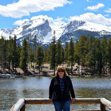
My husband and I always stop to take photos of each other on this small pier on Sprague Lake, and this visit was no exception and I took a few last photos of the moose.


As we left Rocky Mountain National Park to drive back to Fort Collins, the weather was improving, and we had a "goodbye" glimpse of Longs Peak in the distance, peeking through the clouds.  

In my next post, I'll show our drive back along the Big Thompson River and a very special place we found along the way!