Happy Summer!
Every season seems to pass too quickly, doesn't it?
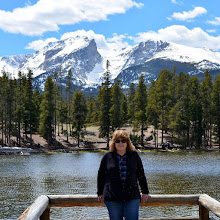
Here is some springtime catch-up on what has been happening with us...

We had a very rainy, cool spring, so everything is very green in our part of Colorado right now.

Our four grandchildren kept us busy all spring with many activities--concerts, dance recitals, an art show, continuation from middle school to high school, two birthdays, and many Lacrosse games

Our spring garden bloomed beautifully, and right on schedule, my June roses bloomed!

We were visited by local wildlife, but thankfully, no bears, mountain lions, or moose have appeared as yet!

We all had fun attending two Colorado Rockies baseball games at Coors Field when they hosted the New York Yankees and the New York Mets!

I was a fortunate winner of this wonderful America's Test Kitchen cookbook called Umma--a Korean Mom's Kitchen Wisdom and 100 Family Recipes from The Book Club Cook Book website this spring.

I've enjoyed making many delicious recipes from the cookbook and have many more earmarked to try in the future!

So, what is ahead for us this summer?
Hopefully, many walks along our local trails with wildflowers growing along the way, and hot summer days cooling off at our community pool. We are also continuing my husband's cardiac rehabilitation routine at our community gym three days a week. Riding the stationary bike while watching beautiful scenery roll by on the screen is almost as good as an actual bike ride!

What are your summer plans?
Please let me know in the comments!
Blogs I link with:
Mosaic Monday, Hello Monday, Through My Lens Monday, Hearth, and Soul Link Party, Anything Goes Monday, You Are the Star Blog Hop, Nature Notes, Home Matters Linky Party, Ducks in a Row, Monday Morning Blog Club, Good Random Fun, Tuesdays With A Twist, Talk About It Tuesday, The Happy Now Tuesday, Wordless Wednesday, Wordless Wednesday 2, Wednesday My Corner of the World, Wonderful Wednesday, Thankful Thursday, Little Things Thursday, Thursday Favorite Things, Skywatch Friday, Generic Link Up, Fantastic Friday, Farmhouse Friday, Dare to Share, Saturday Sparks, Saturday Critters,