The natural beauty of the state of Colorado never ceases to amaze me!
(All photos in this post can be enlarged for easier viewing by clicking on them once or twice)
This is the kind of state where enjoying the outdoors is almost synonymous with breathing. Recreational vehicles, motorcycles, and bicyclists are frequently seen on the roads, going on an adventure.....
...on the many Colorado roads that lead to magnificent views and venues.
One of the adventures my husband and I went on this summer was a car drive to the summit of Mt. Evans.
Mt. Evans Scenic Byway is the highest paved road in North America! Located only 60 miles west of Denver, this scenic highway begins near Idaho Springs, off Interstate 70, at an elevation of 8,700 feet and climbs to 14,130 feet below the summit at 14270. If you begin the drive from Denver's high plains, you will pass through five climate zones. It can be 90 degrees in Denver and 40 degrees, or lower, at the top of Mt. Evans!
One of the first scenic areas you will see on the way to Mt. Evans is
Echo Lake. This pretty alpine lake is at 10,600 feet above sea level and is part of the Denver Mountain Parks system.
There is a recreation fee charged by the
National Forest Service to drive on Mt. Evans Scenic Byway after Echo Lake Park, which is collected for the services and amenities provided at two developed sites within the Mount Evans Recreation area. Because my husband holds a lifetime senior pass to the Federal National Parks, this fee was waived for us.
Only three miles up from the beginning of the Mount Evans fee entrance is the
Mount Goliath Natural Area. It is 160 acres set aside for the protection, study, interpretation, and enjoyment of the Rocky Mountain Bristlecone Pine. Bristlecone Pine is the oldest living organism on earth, some surviving thousands of years!
The short Bristlecone Loop Trail allows visitors to see these mystical looking trees up close.
The
Dos Chappell Nature Center is situated on the edge of the natural area and contains exhibits that interpret the remarkable life that thrives in the subalpine and alpine conditions on the mountain. The trails outside this center were filled with beautiful wildflowers.
As we drove higher on the Mt. Evans Scenic Byway there were many turns and switchbacks that made us feel as if we were driving off the mountainside! There are no guardrails along the road.
I could see Echo Lake receding in the distance.
Higher and higher we climbed...
...and we were soon above the tree line.
We came to a section of the road that always seems to be rimmed with snow...
...even in the month of August!
You can see how Mt. Evans Scenic Byway twists and turns around the mountain range.
We are again sharing the road with bicyclists.
We reached
Summit Lake Park, which is situated below the Mount Evans Massif. At an elevation of 12,830 feet, it is the highest park in the Denver Mountain Parks system. This area is popular for its impressive scenery, alpine botanical features, and wildlife viewing opportunities...
This area is one of the best examples of Arctic tundra in the contiguous United States.
The Summit Lake area provides habitat for a variety of rare alpine-arctic plants, some of which occur only here and above the Arctic Circle. Because of the fragile tundra and rarity of these plants visitors are asked to stay on the trails, and not walk on the tundra. We also saw our first view of the wild mountain rams that live on Mt Evans! They were in the process of shedding their heavy winter fur coats.
The Mount Evans Road significantly narrows after leaving the Summit Lake area. Considering the altitude and extremely adverse weather conditions that exist here most of the year, it is a marvel that this road was able to be constructed between 1924 and 1930. Because the weather changes here so quickly, this portion of the road is often only open from the end of May till the end of August.
Obviously, we drove slowly and carefully as we continued our ascent
We also had to share this rather narrow road with other traffic going both directions.
The views were magnificent for the passenger, but the driver had to keep their eyes on the road!
Finally, we catch sight of the summit! If you enlarge this photo you will see the top dome of the
Meyer-Womble Observatory. Built in 1996, it is at 14,193 feet and is the third highest optical/infrared observatory in the world.
It is easy to see that we are now well above the other nearby mountains, and the tundra land is full of boulders.
This photo shows a look down on the road as we make multiple switchbacks turns along the top.
I really felt as if I was on top of the world!
We arrive at Mt. Evans parking lot, which is at an elevation of 14,130 feet.
Besides the Meyer-Wombie Observatory, there are two historical sites in this area. One is the Crest House ruins. The Crest House was opened in 1942 and served as a restaurant and souvenir shop. It was tragically burned in a propane fire in 1979. The other structure is the High Altitude Lab. It is a wooden double wide A-frame building that was constructed by the University of Denver in 1935 to support cosmic ray research.
My husband and I decided to hike the trail to the very top of the summit.
The thin air at this altitude makes the quarter-mile climb seem more strenuous than it should be, but the views are worth it! From the top one can see the continental divide to the west, including 14,000+ foot Grays and Torreys Peaks. Longs Peak in Rocky Mountain National Park is visible to the north, Pikes Peak, South Park, and the Sangre de Cristo Mountains are visible to the south, and the high plains and the Denver area is to the east.
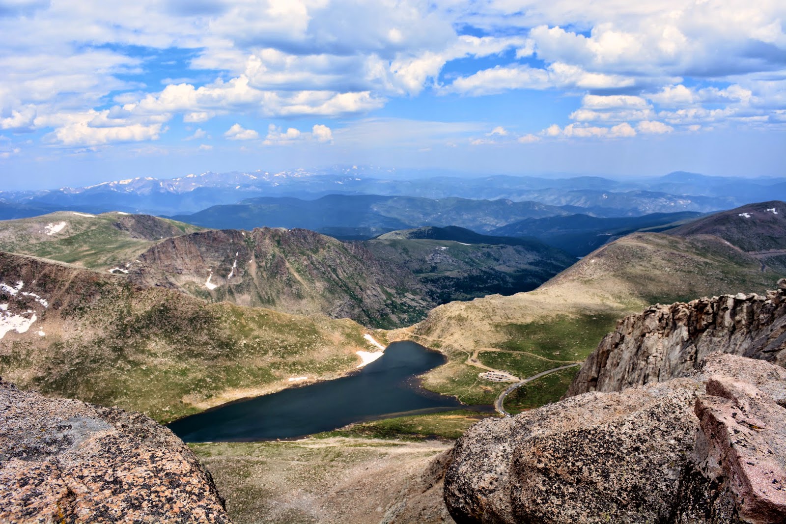
The photo above shows a view of Lake Summit from the summit of Mt. Evans.
More views from the top...
We also saw Mt. Evans Mountain Goats near the summit. They like to lick the minerals from the rocks.
In winter and spring, they have long white furry coats, but they were shedding them in August.
Another visitor took this photo of my husband and me at the summit of Mt. Evans.
We liked it so much that when a representative of
Easy Canvas contacted me and offered me a free 16 X 20-inch photo canvas of a photo of my choice, I chose this one. It came out beautifully! The canvas captured the photo's colors and details perfectly, and the order process was very easy. We hung it in my husband's office, where it will be a reminder of this exciting car trip and hike to the top of
one of Colorado's 53 over 14,000-foot mountains!
The exciting news is that in a post coming up I will be giving away the chance for you to win your own free, 16 x 20-inch Easy Canvas, made from a photo of your choice, and shipped free to your home! Keep checking back on my blog for this giveaway post, which will be coming within the next few weeks!
* In full disclosure this post is sponsored by Easy Canvas. I was given a coupon for a free photo canvas and free shipping. All opinions of the canvas are my own and were not influenced in any way by this gift


.jpg)

.jpg)




 Posts
Posts





