Monday, August 10, 2015

One World Trade Center Observatory, NYC


My husband and I made a visit to New York City for two weeks in July. We were there to celebrate a birthday milestone for my sister-in-law and to visit family and friends. One of the first tourist sightseeing objectives was to visit the recently opened Observatory on the 100, 101, and 102 floor of the new One World Trade Center building in lower Manhattan, and the National September 11  Memorial Museum.   One World Trade Center is the highest building in the Western Hemisphere, standing a symbolic 1776 feet. The Observatory is at 1,250 feet above the city, offering panoramic views through its windows. (All photos and photo collages in this post will enlarge for easier viewing if clicked on)


The morning we arrived there were wispy clouds around those windows in an otherwise bright blue sky.  There were some storm clouds in the distance, so we hoped the good weather would last long enough to give us good visibility.


We had pre-ordered our tickets online prior to our visit. They are pricey, at $32 a person, $30 for seniors, and $26 for children, but we knew it would be worth the cost. Upon entry, guests are welcomed at a Global Welcome Center.


We were surprised to see a graphic that said the day we visited, in early July, there had already been 349,988 visitors to One World Trade Center, from 190 countries!  We walked through a corridor filled with movie screens called "Voices" that told the personal stories of the men and women who built One World Trade Center. My husband was pleasantly surprised to see the face of a steelworker with whom he rode the bus from Brooklyn to Manhattan every day when we lived in Brooklyn. They often conversed about the construction of the tower.  Next,, we passed through an exhibit called "Foundations" which shows the bedrock upon which the tower stands.


Youtube link: https://youtu.be/l_hPh70-W1I

There are five dedicated elevators that bring guests up the 102 floors. While you ride in the elevator a time-lapse video is shown that shows New York City from the year 1500 to the present day.  The Youtube above was the best video I could find of the ride, although it is slowed down somewhat, and the sounds are slightly off.


There is then a two-minute movie about New York City in the "See Forever" theater. At the end of the movie, the screens move up and you get the first view of the city outside the windows.


It is spectacular to look out the tall floor to ceiling windows, North, South, East, and West and see the views!


Unfortunately, the blue skies we saw earlier were replaced by heavy clouds over the city, but it was fascinating to see lightning coming down from the clouds towards the buildings.  Here I was looking North towards uptown.  The Hudson River is to the left.


Closer...


Zooming in with my camera, I could see the Empire State Building in the distance...


...and an even closer view!


Do you see the tall skinny building in the background of the photo above?  Almost completed in construction, and at 96 stories high, 432 Park Ave is the tallest residential building in the Western Hemisphere.  Penthouses there will cost close to 100 million dollars!  Unbelievable!


There are round "City Pulse" screens on the observation deck with HD video monitors that help visitors pick out landmarks on the horizon.


Looking North East at the East River and the boroughs of Queens and Brooklyn in the distance.


A closer look at the Manhattan Bridge upper left and the Brooklyn Bridge, lower right.


An even closer look at the Brooklyn Bridge.


Looking southeast, I could see Lower Manhattan and Governors Island, with some of the shorelines of Brooklyn.


A closer view of Governors Island -- click here to read my blog post about this island.


More views of Brooklyn to the South East...


...and in the Distance the Verrazano Bridge that connects Brooklyn with Staten Island.


To the south, we could see the Statue of Liberty on Liberty Island and near it, Ellis Island.


Closer view of both and...


...closer view of the Statue of Liberty.


To the West, we saw the Hudson River and New Jersey.


More views West to New Jersey.


Back around looking North towards upper Manhattan. 


If I looked directly down the windows I saw some landmarks I recognized.  In the upper left in the collage above is looking down towards Church Street and the unusually shaped Oculus Transportation Hub building. The upper right photo shows one of the 9-11 Memorial pools, on the lower left is the Irish Hunger Memorial--click here to read my post about that, and the lower right looks down on the golden brown-hued Stuyvesant High School. Stuyvesant is a specialized high school for mathematics. science and technology, and is one of the premier high schools in the United States.


The elevator rides down from the Observatory is another one-minute video experience that makes you feel as if you are descending outside the building.


No matter how you look at One World Trade Center...


....whether near...


...or far, it is an interesting building to see, and an amazing one to visit!


Bookmark and Share

Sunday, August 2, 2015

Pikes Peak or Bust!


There it is--Pikes Peak! At 14,115 feet it is called "America's Mountain."The saying "Pikes Peak or Bust" was a familiar slogan when I was a child. It was a saying that became popular during the Colorado Gold Rush of 1859 when over 100,000 men rushed west to the Rocky Mountains in search of gold, and pioneers headed west with hopes for a better life. It later became a rallying cry used when someone was trying to describe a dream they hoped to accomplish by every means possible. The phrase certainly fired my imagination! (All photos and photo collages will enlarge for easier viewing if clicked on)


The story of Zebulon Pike's discovery and attempted conquest of the mountain names after him. Click on the photo to enlarge it. This placard is located on the Riverwalk in Pueblo, Colorado.
This is the third summer we've lived in Colorado, and even before we lived here, I wanted to drive up this mountain that I heard so much about my entire life. My husband and I decided last weekend that the day had finally arrived when we would drive south to Colorado Springs and conquer the mountain! It was not without some trepidation, as last summer we found the drive up the equally high Mt. Evans (click here to read that post) quite a thrilling drive, and we were a little nervous if the road up Pikes Peak would prove to be the same, and if the weather would cooperate with our drive.


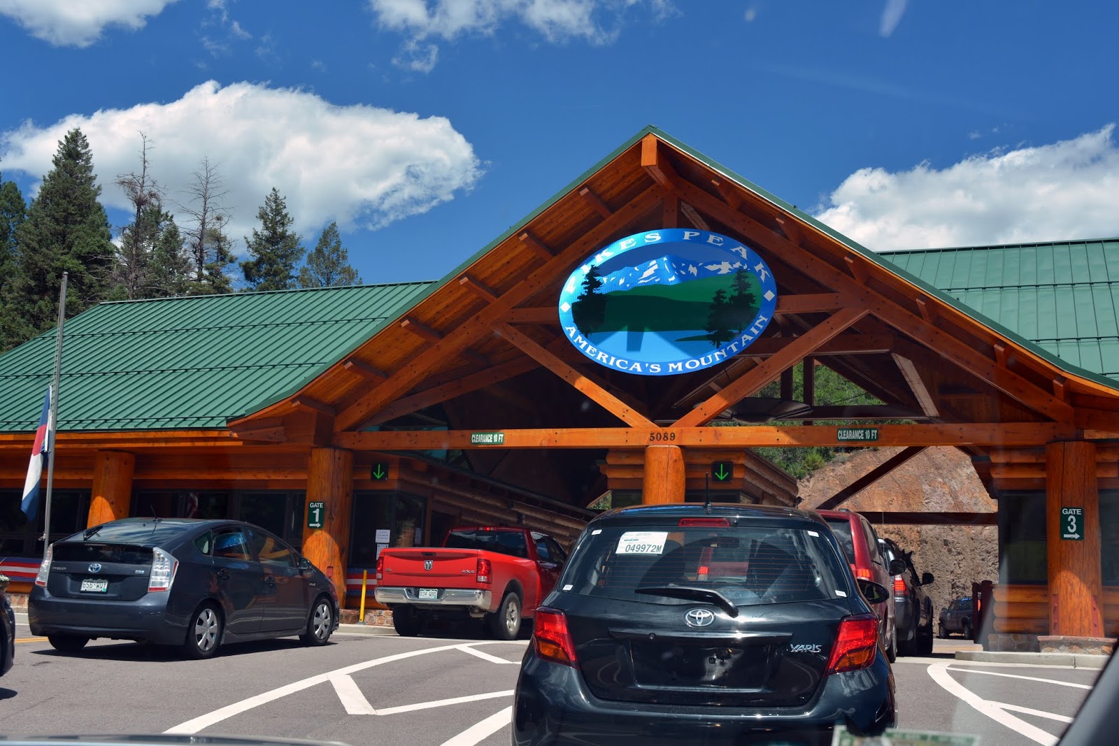
We paid the fee to drive up the 19 miles long Pikes Peak Highway at the road's toll gate and we were on our way!


The road was wide and well paved. We were advised by a ranger at the beginning of the highway to make sure we had half a tank of gas and to keep our car's air conditioner off.


The road was definitely rising higher with each turn, but it did not feel too precarious.


We passed gentle slopes of pine trees for much of the first miles


As we climbed higher the terrain became rockier.


As a passenger, I could see the Pikes Peak Highway and valley views behind us as we drove higher.


We were soon driving above the tree line, at over 11,000 feet, and were at about the 13-mile mark on the highway. You can read about the different climate zones the Pikes Peak Highway passes through on this link.


There were stops along the way on the highway, that allowed visitors to explore different areas of the mountain, but we wanted to drive straight up and not stop, as we were hoping to avoid the usual thunderstorms that occur most afternoons. There is an area near this point called the "Devils Playground" due to the way lightning dances from rock to rock during a thunderstorm.  That must be a sight to see!


The views on the way up the mountain were breathtaking!


As you can see from this photo, the highway is composed of many long switchbacks, which makes the drive up easy to navigate.


Even though this was the last weekend in July. we saw patches of snow!


More winding road ahead.


The higher we rose in elevation,  the more desolate the terrain appeared, full of tundra grasses, mosses, sedges, and lichens. It is at this altitude that the Colorado State Mammal, the Rocky Mountain Bighorn Sheep live, but we did not see any on our journey up.


I had a wonderful view of Glen Cove and Crystal Creek Reservoir in the distance.


At one time the last few miles of the Pikes Peak Highway were not paved, but now the road extends all the way to the summit. At this point, the driver can really feel the high grade and sharper turns, but we both felt quite safe.


It was thrilling to feel as if one was driving into the clouds!


We finally reached the summit!  The summit is very wide and flat with plenty of parking space.  We could see the Summit House, which is a gift shop and cafe, and a marker bench sign.  There is also an Army weather station on the summit that is not open to visitors.


Some of the summits were extremely rocky...


...but there were plenty of areas that enabled magnificent panoramic views!


Again, the sensation we had of almost being able to reach up and touch the clouds was mesmerizing!


My husband and I hopped up onto the Pikes Peak bench to have our photo taken.


We then walked around the summit to enjoy all the views! 


Thankfully, the weather remained good for our entire visit! The weather at Pikes Peak summit can easily be 30 to 40 degrees cooler than the weather at the base of the mountain, but since it was a 90-degree day in Colorado Springs it was a tolerable 55 degrees at the summit. You can check the present weather on Pikes Peak at this link.  Also, it is good to remember that at this altitude you are only breathing 53% oxygen!  If you are visiting Colorado from another state, and have not acclimated your body to the lower level of oxygen at a mile high, you will certainly feel the effect of being almost 3 miles above sea level!


From an observation deck, we could see visitors exploring the terrain.


We also watched hikers reaching the summit from the Barr Trail that ends at the summit near the Cog Railway tracks. Hiking the trail is a feat of endurance as it is 13 miles long and rises 7,510 vertical feet in elevation from its base, and that is one way! 


Also, located on the observation deck, is the "America the Beautiful" monument, as well as other memorial plaques.  In 1893, Katherine Lee Bates, an English teacher from Wellesley College in Maine was invited to teach a summer reading course in Colorado Springs. She was so impressed by her 2,000-mile journey west and a visit to the summit of Pikes Peak that she composed the poem/song America the Beautiful. You can read the entire story at this link.


There was another plaque in an area near the parking lot that caught my attention.  It was a memorial plaque for Carl Lotave, who died in 1924 and whose ashes were interred underneath it. Lotave was a Swedish-born artist who became famous for his portraits and scenes of the southwest and Native Americans for the Smithsonian Museum.


Another summit view.


The ruin of the original Summit House that was built in 1873. A timeline of the history of Pikes Peak can be read on this link.


For those that do not wish to drive up and down the summit of Pikes Peak, you can take the Cog Railway. My husband and I hope to take the railway one day to have this experience, and I will definitely blog about it.


Sorry for the blurry photo, but I wanted to show you the famous Pikes Peak donut that you can buy inside the Summit House.  They are the only donut in the world made at over 14,000 feet, using a secret recipe.  They are light and delicious! You can watch a Youtube video about the donuts on this link. 


After enjoying the summit of Pikes Peak for a couple of hours we decided it was time to head back down the mountain and return home.  We were surprised to see that even in the late afternoon there were still many cars making the ascent.


Again, the views were outstanding!


Wildflowers growing among the boulders.


We followed instructions to drive down the mountain using low gear, and to try not to use our brakes continuously.


I could feel the decent grades much more than on the ascent going up.


Some of these rocks that we passed seemed precariously balanced!


We slowly descended back to the subalpine and Montana regions of altitude. 


At the halfway point, near the Glen Cove Inn, cars are asked to stop by a Ranger for a brake check.  If your car's brakes are not overheated you can continue on your way. If your brakes show signs of stress you are asked to pull over for a length of time in the inn's parking lot to allow them to cool, for your safety.  The Glen Cove Inn has restrooms and a restaurant and a gift shop.  Happily, our brakes were good so we continued on our way.


Soon we were back to the entrance area of the Pikes Peak Highway, completing our trip and another wonderful Colorado adventure!


One last look at Pikes Peak on our way home.  We did it! "Pikes Peak or Bust!" We conquered the mountain and I know we will be back to do it again someday!


Bookmark and Share