

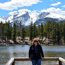
Waterton Canyon in Littleton, Colorado, is a well-maintained 12.4-mile round-trip trail along the South Platte River for hikers, bikers, fishermen, and horseback riders, and ends at the Strontia Springs Reservoir and Dam. It is also a road for Denver Water employees to access the canyon facilities and the Strontia Springs Reservoir.

The canyon is home to mule deer, bighorn sheep, bears, rattlesnakes, and more than 40 species of birds. No dogs, leashed or off, are allowed on the trail to protect the bighorn sheep.

Please click on the photo above to enlarge the trail map of Waterton Canyon.
The 567-mile-long Colorado Trail #1776 (Segment 1) begins at Waterton Canyon and ends in SW Colorado near Durango, Colorado.
The Colorado Trail website states: "Mile for mile, the most beautiful trail in America… built and maintained by the volunteers of The Colorado Trail Foundation.
Since its completion more than 35 years ago (Trail History), the Colorado Trail has become known as one of the premier long-distance trails in the country, lauded by hikers, backpackers, mountain bikers, and horse riders from around the world. The CT comprises 567 miles of trail between Denver and Durango, and it passes through some of the most spectacular scenery in the Colorado Rockies. Users traveling end to end encounter the high mountain lakes and towering peaks of six wilderness areas and eight mountain ranges as they climb nearly 90,000 vertical feet. The average elevation of the Trail is 10,300 feet, topping out at 13,271 feet just below 13,334-foot Coney Summit in southwest Colorado.
You can watch a short five-minute video with photos of the trail on this YouTube link,
You can also watch a 27-minute PBS Colorado Experience Show on this YouTube link about how the Colorado Trail was built and maintained by volunteers.

Click on to enlarge
As my husband and I began a short hike along the Waterton Canyon Trail, we passed this water station at the beginning, which told us there would be no further drinking water along the trail.

It was early morning, and we saw bicycle riders. backpacker hikers and people ready to go fishing in the river.
There are 16 different kinds of fish in the river!

The Waterton Canyon Trail is a wide, compact dirt trail and fairly flat for the first few miles.

Please click on to enlarge
We stopped to read this placard.
Information from the Denver Water website:
"In 1902, the Platte Cañon Filtration Plant, later renamed Kassler, was opened at the base of Waterton Canyon by the present-day Chatfield Reservoir. Kassler, which used the English slow-sand filter process, was the first of its kind west of the Mississippi River.
Kassler’s underground infiltration galleries were built in 1890, the filter beds completed in 1906, and the reservoir and pump station were built in 1972. A whole town was built around the plant to operate and maintain the facility. At the height of its operation, Kassler delivered more than 50 million gallons per day of treated drinking water to the residents of Denver. It was named a national water landmark in 1979.
By 1985, Kassler ceased operations because it was unable to keep up with demand. Now the buildings and nearby facilities are used for educational purposes."

Please click on to enlarge
At a rest station/picnic area, we saw the placards above.
The first placard tells the story about the middle and late 1870s, when the Denver, South Park and Pacific Railroad constructed the first railroad through the canyon and through the valley of the North Fork to South Park and eventually to Leadville and Gunnison. The line was initially a narrow gauge and was later acquired by the Colorado and Southern Railway. Service on the line was terminated in 1937.
The second placard tells the story of the Berens family, Leroy and Mary, who had a homestead at this location in 1923 and raised two daughters here.

The river water was flowing well!

We saw a wooden bee home for solitary bees along the way....

...and many wildflowers and shrubs...

...many Cottonwood Trees, already shedding their cotton-like seeds...

We saw a few female Bighorn Sheep...

..a giant ant hill...

..and a very large Bull Snake!

We hiked past the pipeline in Waterton Canyon that feeds water from the South Platte River to Denver Water’s Marston Treatment Plant.

We hiked about three miles, and when we returned to the parking lot, we saw horses being unloaded
to go horseback riding along the trail.
What a fun way that must be to see the entire length of the trail!

As we drove towards the highway to go home, the sky along the Platte River looked particularly beautiful with wispy clouds.

The Platte River leads into the Chatfield Reservoir.
The dam and reservoir were built by the United States Army Corps of Engineers as a response to the disastrous flood of the Platte River in 1965. In addition to its primary purpose of flood control, it serves as one of many water supply reservoirs for the city of Denver, Colorado.
You can read a blog post I wrote about a flood that occurred a few years ago at this reservoir on this link.
Sadly, this year has been a drought year for Colorado, although I read that this reservoir level is doing well, so far.
We hope for more rain!
I can also be found on
Blogs I link with:
Nature Notes, Home Matters Linky Party, Happiness is Homemade, Monday Morning Blog Club, Senior Salon Pit Stop, Talk About It Tuesday, The Happy Now Tuesday, Happy Tuesday, Wordless Wednesday 2, Wordless Wednesday on Comedy Plus, Wonderful Wednesday, Thankful Thursday, Weekend Traffic Jam Report, Thursday Favorite Things, Skywatch Friday, Weekly Wisdoms, Fantastic Friday, Farmhouse Friday, Crazy Little Lovebirds Friday Link Up, Dare to Share, Saturday Sparks, Saturday Critters,


32 comments:
The Waterton Canyon trail looks beautiful. It's interesting to read the history of these trails and of the ways people lived on the land in the past. How great that you got to see the Bighorn sheep!
Colorado is a picture perfect place. And those ants, well let's just say, my skin started to itch after seeing the hill! The whispy cloud image looks 3D!
Thank you for sharing.
All the best.
Debra @ Life Captured
What a lovely hike! You saw some gorgeous scenery. The sheep are cute - not so sure about the snake!
That looks like a fantastic place to visit and it is good that no dogs are allowed to protect the wildlife. Brilliant photos!
Another wonderful trip with great natural beauty. I do thank you for taking me to places I can no longer visit in person. #MMBC
Wow! This is so neat. I had no idea the trail was so long. What a lovely stop you had (although I never enjoy any type of snake in any setting!). How lucky to see the bighorn sheep. :) Visiting from the Happiness is Homemade blog party.
I walked virtuelle with you. A very interesting path and I enjoyed reading very much.
Thank you for sharing at MosaicMonday
Greetings by Heidrun
You do hike very interesting places, and I love reading about it
It's so wonderful to have trails like these!!
Hello Pat,
Nice hike, the views are pretty. I always enjoy the views of a river and a lake. I am glad the snake was moving away. The bighorn Sheep are a treat to see. Pretty blossoms. Great photos. Happy June! Take care, enjoy your day! Happy week ahead!
Hubby and I would enjoy these walks. How delightful and so beautiful. A great place to enjoy.
Thank you for joining the Happy Tuesday Blog Hop.
Have a fabulous Happy Tuesday, Pat. ♥
This looks like a trail I would love to hike.
What an amazing hike! I can't believe all the things you saw -- it's truly beautiful and I see why it gets its name. I'd love seeing those sheep but I'd pass on the snake! I love that they told you it was the last water station for a long while. And the history is interesting too.
Thank you for joining the Wordless Wednesday Blog Hop.
Have a fabulous Wordless Wednesday. ♥
Thank you for the visit. I admire your images, beautiful and interesting.
I'm glad I made this tour...
Happy WW and a fine Summer!❤️😘
That sounds lovely! I really like your tree/plant photos.
The CT sounds fascinating. I've not heard of it before, but it sounds like it passes through some spectacular scenery!
A beautiful hike with amazing scenery. You live in a special state! Thank you for linking up!
...the 12.4-mile Waterton Canyon trail is a bit too long for me. I'll just enjoy the pictures, thank you!
Snakes, ants and sheep. Creatures all so different and unique in their wonderful ways. :)
Lovely hike.
Looks like a great hike.
What a wonderful walk through! The bighorn sheep, wildflowers, and flowing South Platte River made for beautiful sights, and that Bull Snake was quite a find.
What a great trail. I enjoyed hiking with you from my study chair. Colorado is such an interesting state.
What an amazing place for a hike. Loved your photo. You can almost feel the heat of summer starting to come in.
Amalia
xo
What a wonderful place for a hike! I would love all of this apart from the snakes. Just the thought of them! 😬
Thanks for taking us along, Pat.
I never heard of the trail before but now I'd like to try parts of it... Lot's of vertical hiking though!
Colorado is an absolute playground for outdoor enthusiasts.
Worth a Thousand Words
Hello Pat,
You had some nice wildlife sightings on your walk.
I do not mind seeing the snakes, from a distance.
The sheep are cool critters, love the horses too.
Thank you for linking up and sharing your post. Take care, have a great day and a happy weekend! PS, thank you for leaving me a comment.
Wow, that trail sounds amazing to hike. And I love the history you gave. Your photos are amazing too.
Visiting today from WTJR
Beautiful! You know, living here in Colorado, I've never gone to this trail. I'm adding more trails and hiking spots to our list as time goes on. Pat, I always enjoy your posts, and we appreciate you sharing them with us at The Crazy Little Lovebirds link party.
Ps: Thanks so much for sharing with Sweet Tea & Friends this month dear friend.
Post a Comment