Sunday, March 6, 2016

The Four Corners in the Navajo Nation


After viewing the Mesa Verde National Park in SW Colorado--see this link to view that post--my husband and I stayed in a hotel overnight in Cortez, Colorado. Early the next morning, we began to drive South on US 491 and then SW on US 160 towards the Four Corners area that borders the states of Colorado, Arizona, New Mexico and Utah.  The scenery in Montezuma County in Colorado is so magnificent!  Ute Mountain valley was lit in golden hues by the sunrise.  The Ute Mountain Ute Tribe Reservation town of Towaoc is located here, and as we passed by we saw some of their ponies running wild alongside the road. (All photos and photo collages in this post will enlarge for easier viewing if clicked on)


As we drove South West on US 160 towards the Navajo Nation. The Navajo Nation is one of the largest Native American tribal governments of the North American Indian Nations, with a land base larger than the US state of West Virginia.  It occupies portions of northeastern Arizona, southwestern Utah, and northwestern New Mexico. You can read more about the history of the Navajo Nation on this link.


Please click on collage photo to enlarge

We passed the most amazing topography along the way in this area that is part of the Colorado Plateau.  Comprised of arid desert areas and mesas the land showed evidence of wind and water erosion and past volcanic activities, all which carved this land over the ages.  While beautiful, it also looked very inhospitable to human existence.


We soon reached our destination within the Navajo Nation of the Four Corners area, the only place in the United States where four states corners connect--the states of Colorado, Utah, Arizona and New Mexico.


Here, the Four Corners Monument is located. This area is very remote, with no running water and no electricity.  The visitors center is opened almost year round, and features a demonstration center with Navajo vendors that sell crafts and traditional foods.  We arrived very early in the morning, and  the vendors were still arriving and setting up their booths.


The original Four Corners marker was placed in this spot in 1912 with a simple concrete marker, but over the years the monument has been built up with granite and brass to be a more imposing place to visit.
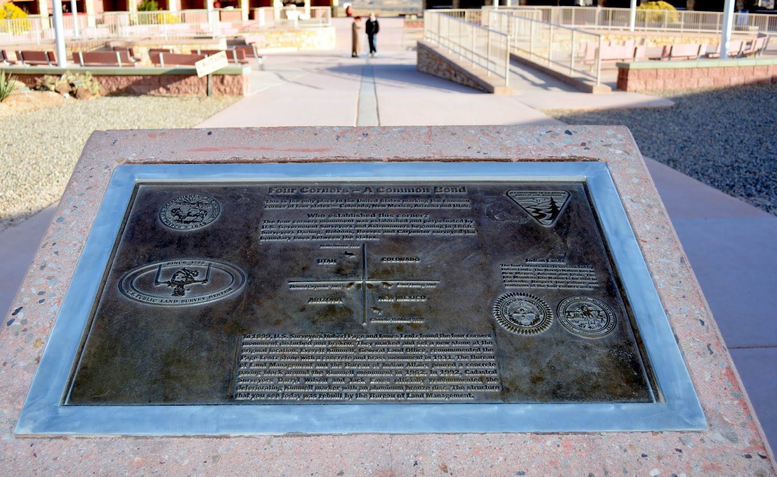

You will have to click on to enlarge the historical placard above at the Four Corners site that explains the history of how this site was marked by surveyors in 1868.


There, in the middle of the monument park, is a US Department of Interior metal disk that marks the exact spot where the corners of the four states touch, surrounded by markers which tell you the locations of the four states.


A closer view....

The words around the perimeter of the circle states: "Here meet in freedom under God four states."


...and even closer.


The four states and their state shields surround the marker.


My husband and I standing in two separate states each....


...and my brave husband with a limb in all four states!

It was exciting to visit the Four Corners Monument and see a portion of our country that is so unique for its location as well as for the views of the Navajo Nation and to meet the indigenous native peoples that were able to prosper here, and blend both traditional and modern ways of life.


A view of the beautiful, but desolate, land surrounding the Four Corners Monument.


We were soon back on on the road, and passed over the Arizona border, on our way to Gilbert, Arizona, where my sister-in-law and brother-in-law live, and where we were gathering for our niece's wedding. We had many miles ahead of us, but we were glad we decided to drive to see these fabulous sights. We were still driving through Navajo Nation, and in my next post I'll show more of this very unique and beautiful place.


In Memoriam


I was very sad to hear that Sally of the blog Smiling Sally, passed away last week. Sally hosted a blog event called "Blue Monday" for many years, as blue was her favorite color. I always tried to participate in Blue Monday as much as possible, as I enjoyed getting to know Sally through her blog and also on facebook. As a retired high school teacher, she also enjoyed reading very much, and also had a book review blog. Sally had a wonderful sense of humor, was positive through all her health struggles in the past few years, and had a wonderful deep love of family and faith, which she expressed often in her blog posts. I know she is happy to be with our Lord Jesus in heaven. Good bye, Sally---I will miss you and you will always remain in my heart and prayers.


I'm linking this post to the following blog events:

Thank you to all the blog hosts!

Bookmark and Share Pin It

Sunday, February 28, 2016

Mesa Verde National Park


Last autumn, my husband and I drove to a family wedding in the Phoenix, Arizona area. We wanted to drive, instead of fly, in order to see more of this beautiful area of country.  One of the places we stopped to see on our two day drive to Arizona was Mesa Verde National Park.  The park is located in southwestern Colorado, midway between the towns of Cortez and Mancos, off US 160. From the highway to the park headquarters it is 21 scenic miles -- about a 45 minute drive.

Mesa Verde means "green table" in Spanish, named after the forest that covered the mesa. The Mesa Verde National Park offers a spectacular look into the lives of the Ancestral Pueblo people who made it their home for over 700 years from AD 600 to 1300. Today the park protects nearly 5,000 known archaeological sites, including 600 cliff dwellings. These sites are some of the most notable and best preserved in the United States. (All photos will enlarge for easier viewing if clicked on)


About 15 miles from the highway is the Far View Visitor Center. The visitor and research center opened in mid December of 2012 and replaced the old facility. It houses a state of the art research center and is a storage facility for the park's archives and museum collection of over three million objects. It also features exhibits that focus on the contemporary American Indian cultures in the Four Corners area. The visitor center is also the area to pay the park entrance fee and buy tickets to enter some of the cliff houses on a ranger led tour.


After stopping at the visitors center to see the exhibits, we began our drive up to the top of the mesa, at an elevation of 7,000 to 7,500 feet.


The views along the long drive up were magnificent!  The park recommends at least a 6 hour visit to see all of its features. We were arriving in late afternoon, so we knew we would have to condense our visit as much as possible to just see the park's highlights.


Once we arrived at the top of the mesa we were amazed to see the deep open canyon that cuts through the park!


The very first archaeological sight we viewed was the Cliff Palace.


Cliff Palace is an exceptionally large dwelling which may have had special significance to the original occupants.  It is thought to have been a social, administrative site with high ceremonial usage.


The Cliff Palace contained approx 150 rooms, and 28 kivas, and had a population of around 100 people. The Kivas are round or rectangular rooms used for ceremonial purposes. The detail of the buildings was very well preserved considering their vast age


Two cowboys discovered Mesa Verde, specifically the Cliff Palace area, in 1891.  You can read their story on this link.  Mesas Verde was made a National Park in 1906 by President Theodore Roosevelt.


Next, we drove to the viewpoint for the  "House of Many Windows."  Can you see it in the wall across the canyon?


Please click on the photo above to enlarge this placard at the site that explains more about the House of Many Windows


I zoomed in to see this remarkable structure. Isn't it amazing that this structure was built right into the walls of the canyon?


A closer zoom to see more of the detail.  Supposedly the windows  were really doors, that were once covered with animals skins or a stone slab. There are eleven rooms and a kiva on a 19 foot wide ledge.


The next area we visited was a structure called the "Pit House." The Pit House was a structure partly dug into the ground, and covered by a roof of some sort. It provided shelter from the weather and was also used to store food and for cultural gatherings and celebrations.

If you click on the photo collage above you can read area placards that tell more about the Pit House structures and their uses.  Most of the ancient Pueblo people lived this way on the mesa top, until they began to build the cliff dwellings the last 75-100 years of occupying Mesa Verde.


Look closely, and in the middle of the rocks in photo above, you can see our next stop--a view of the Navajo Canyon Overlook. Navajo Canyon is 700 feet deep and 15 miles long. It contains 60 cliff dwellings.


Next, we visited "Sun Point View."  As you can see by these photos the late afternoon sun was shining very brightly on the structures.


Close up of Sun Point View.  Archaeologists theorize that the ancient peoples that built these structures did so for protection against enemies, as well as storms and other environmental hazards. One can see how secluded, and hard to reach, that they were within the canyon's walls.


Click to enlarge this photo to read about our next stop, "Oak Tree House."


Oak Tree House held about fifty rooms and six kivas. It was multi level and made the most use of its alcove space.


Another structure that was still standing on the mesa top, was the "Sun Temple."  According to modern Pueblo Indians, the Sun Temple's features classify it as a ceremonial structure. Construction of this structure does not appear to be finished and it is thought that the ancient people left the area around that time.  By 1285, following a period of social and environmental instability, and severe and prolonged droughts, the people began to abandon the area and moved south to locations in Arizona and New Mexico.  By 1300, the Ancestral Puebloan occupation of Mesa Verde ended.


We had almost made a full loop around and we saw the sun was beginning to get low in the sky, so we hurried along to see as much as we could.


Now instead of being at a view point next to the Cliff Palace that I showed earlier, we were directly across from it.


 From this perspective you can see how well protected and hidden the structures are from the top of the mesa.


A closer look at the structures.


The last area we viewed was "Spruce Tree House."


Spruce Tree House is the third largest cliff dwelling.  It was constructed between AD 1211 and 1278. It consisted of about 120 rooms and eight kivas, and built into a natural alcove measuring 216 feet at its greatest width and 89 feet at its greatest depth.  It is thought to have housed 60 to 80 people. As you can see in the photos above there was a ranger lead tour going on in the buildings. We hope to return one day to spend more time in Mesa Verde and take some of the cliff dwelling tours.  Visitors have to climb up and down steep vertical ladders to do this, so being in good physical condition to take the tours is important.


Although our visit was short, we really enjoyed our visit to Mesa Verde National Park, and we know we will return to see more of it in the future.


Our drive back down the mesa was lit by the glorious golden glow of the setting sun, and we were soon in our hotel room in Cortez, Colorado. The next day we were going to drive west to Navajo Nation where we were going to visit the Four Corners.  Please come back to read my next post to see the corners where the states of Colorado, Arizona, New Mexico and Utah meet!


I'm linking this post to the following blog events:

Thank you to all the blog hosts!

Bookmark and Share Pin It
