Showing posts with label Buena Vista. Show all posts

Monday, October 21, 2024

Autumn Beauty Along Cottonwood Pass


On the second day of our stay at the Mt. Princeton Hot Springs Resort—click here to read about the resort—we decided to drive to the nearby Cottonwood Pass. 
Cottonwood Pass is a 56.8-mile stretch of paved, winding mountain road connecting Buena Vista and Almont, Colorado. It summits at the continental divide (at 12,126 ft elevation) and features some of Colorado’s best hiking trails, campsites, and mountain vistas
It's a stunning mountain pass known for its colorful fall aspen groves, and we hoped to still be able to catch some autumn color during our drive.


Cottonwood Pass is in the Sawatch Range of the Rocky Mountains. The road over Cottonwood Pass is the highest paved crossing of the Continental Divide in the U.S. The area surrounding the pass is mostly forest, with the San Isabel National Forest to the east and the Gunnison National Forest to the west.

It was the second time we drove over Cottonwood Pass--click here-- to see that late summer drive where we followed the pass all the way to its end in Almont
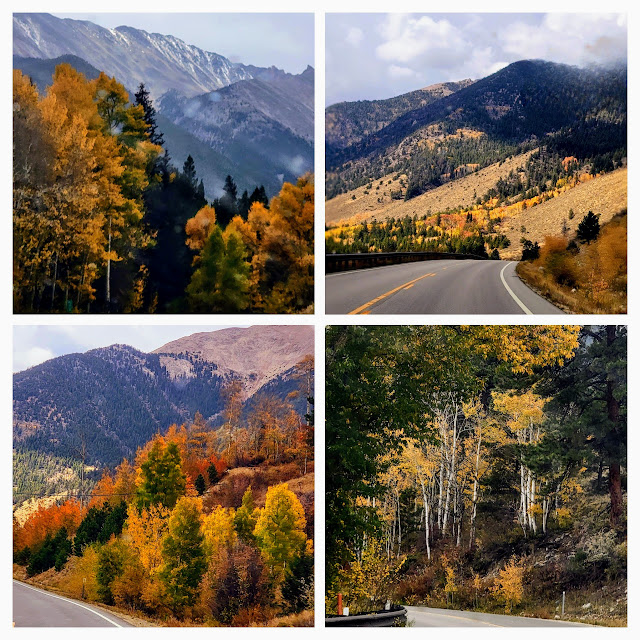

We were thrilled to see that the autumn colors were still vibrant! Bright patches of orange and rust foliage mingled beautifully with the golden aspens.


 Clouds were building up and a few raindrops fell at times and we drove along the winding road.

More bright colors!

\\
We passed some very tall aspens and many cottonwood trees.


As we drove higher there were more pine trees and scrub brush.


Eventually, we were above the tree line


We parked for a while at the summit and seeing heavy clouds and sleety snow that began to fall, we decided not to drive further but to return to Nathrop.


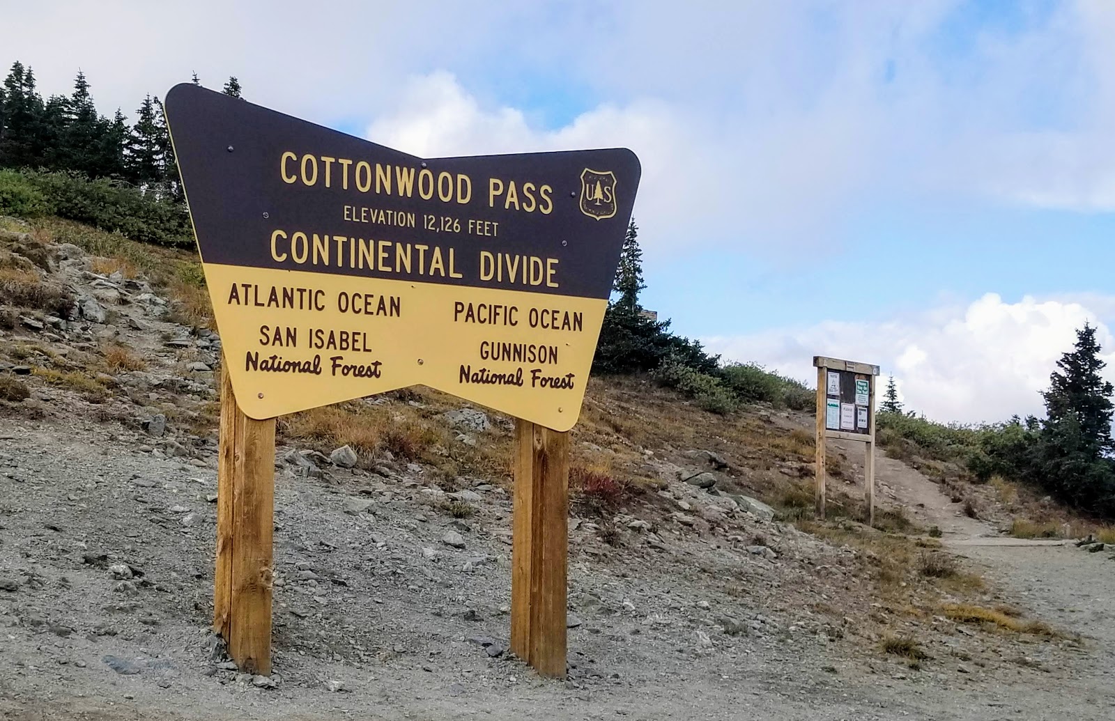
We did take the obligatory photo of the summit sign!

Driving back down...


...passing the autumn scenery from the other direction

Passing a lake area as we approached Buena Visita.

A last look back at the mountain peak we just drove down from.


Looking at the mountain range in the distance we knew we made the right decision to turn back, as heavy clouds were in that area and it was probably raining or snowing at the higher elevation. Because of high snowfall, Cottonwood Pass closes for the winter, usually in November, and reopens in May

Later that evening we drove to the charming town of Salida for dinner--on my next post

Please join me again on my blog next week!


Monday, April 20, 2020

Buena Vista, Colorado


How is everyone holding up during this COVID-19 Pandemic?  I was so worried about the spike in cases raising higher and higher across the USA and the world that I found it difficult to be online last week and took time off to do other things. I finished a few books I was reading, cooked and delivered Easter dinner to my children, watched some wonderful musicals and theater productions on TV, video conferences with family and friends on Zoom, and even ventured out to shop in Costco while staying very careful by wearing a mask and continuing social distancing. We have relatives in northern and southern Italy, and in New York City--both places severely affected by the novel coronavirus--so we were particularly stressed and worried. Thankfully, all our relatives remain well. Sadly, we did hear of many who passed away from this vicious virus--friends of friends, parents of children my children went to school with, neighbors and co-workers of other friends. Each life lost is a tragedy.  I know there are plans to begin to "reopen" and return to some areas of regular life, but my husband and I, being older, will continue to social distance, wear our makes when out, and stay home as much as possible. Most likely we will do this until a successful vaccine is developed. The hardest part of this regime is staying distanced from our children and grandchildren. I will never take hugs for granted again! 


Happily, my husband and I always loved to travel, and I have much in my files to blog about.  I've been reminiscing the past few months about a wonderful road trip we took to central Colorado last autumn, in the Sawatch Mountain Range area, where we enjoyed many locations in that locale. I realized I did not highlight the town we used as our base on all our separate drives, the charming town of Buena Vista. Buena Vista means "Good View" in Spanish, and as we approached the town from US Route 285 west, you can see how it acquired its name with its mountain vista.  We were fortunate to see an afternoon rainstorm over the mountains as we arrived--quite a sight to see!


This was in mid-September, so the trees were beginning to show their autumn color, and it was still warm enough that there wasn't any snow in the mountains as yet.


Buena Vista is located in central Colorado roughly midway between Salida and Leadville in the Upper Arkansas River Valley at an elevation of 7,965 feet.  The town's name is pronounced BYOO-nah VIS-ta by most locals. It was named by Alsina Dearheimer, a settler from Germany, who suggested the name with its unique pronunciation when it was incorporated as a town in 1879. Mining, agriculture, and ranching were the main occupations at the time.  Tourism is now a major draw of the area.


We stayed in a small local motel where this beautiful view of the mountains greeted us every morning from our window! From this location, over the next few days, we visited the artsy town of Salida, the Mount Princeton Hot Springs in nearby Northrop, the picturesque St. Elmo Ghost Town, drove over the newly paved Cottonwood Pass into Crested Butte, back to Buena Vista over Monarch Pass, up into the mountains to see the ghost towns of Vicksburg and Winfield, and then a side trip to Leadville! Click on any highlighted word to read those blog posts.


With mountains on one side and the river on the other, Buena Vista is a haven for outdoor enthusiastsNumerous rafting companies are based around Buena Vista, offering guests thrilling whitewater rafting trips on the Arkansas River. Anglers also share the river, which was awarded Gold Medal Trout Water by the Colorado Parks and Wildlife Commission.


On the west side of the valley, Buena Vista offers convenient access to numerous fourteener trailheads. Here is the highest concentration of 14,000-foot peaks in the lower United States, with 15 peaks over 14,000 feet elevation in the area, including 14,433 foot Mt. Elbert, the tallest mountain in Colorado.


The beautiful Browns Canyon National Monument is in the area with 21,586 acres of pristine canyons, rivers and backcountry forests. One can enjoy backcountry hiking, horseback riding, and snowshoeing and cross-country skiing in the winter.


The town of Buena Vista retains much of its Victorian-era charm. I enjoyed strolling around its downtown area one evening between our many excursions.


We dined at a local family restaurant called Quincys Tavern where the menu is simple and the quality is exceptional! We couldn't believe the price of the delicious filet mignon dinner that we enjoyed, complete with a salad and dessert. I highly recommend it if you visit Buena Vista or one of their other four locations.


"Free Bear Hugs"

Some cute carved bear statues for sale on the main street in Buena Vista.  

I think right now a bear hug sounds good--any kind of hug sounds good!  Let's hope it won't be long before hugging and traveling and life as we knew it returns in time. How are you coping in this strange new world?  Stay well!

You can also find me on 


I'm linking this post to the following blog events:

 Mosaic Monday, All SeasonsBlue Monday, Through My Lens MondayLittle Cottage Link Party
 Hearth, and Soul Link PartyYou Are the Star Blog Hop, Inspire Me Monday,  Good Random FunNature NotesGrand SocialTravel Photos, Photo TunesHappiness Is HomemadeOver the Moon, Our World TuesdayRuby TuesdayTuesday Turn AboutTuesdays With A TwistLet's Keep In TouchWordless Wednesday on a TuesdaySay Cheese!,  Party in Your PJ'sWordless WednesdayNanahood WWOh My Heartsie Girl's Wonderful Wednesday, Your Whims WednesdayWorldless  Wednesday My Corner of the WorldWonderful Wednesday Little Things ThursdayThankful ThursdayThursday Encouraging Hearts and HomeFull Plate ThursdayFriendship FridaysFriday Features Linky Party, Skywatch Friday,   Pink SaturdaySaturday Critters
 Grammys Grid-Month Long Linky Party

Bookmark and Share

Monday, March 9, 2020

Ghost Towns of Vicksburg and Winfield, Colorado


In autumn of 2019, my husband and I took a scenic drive in Colorado into Clear Creek Canyon, between Buena Vista and Leadville, Colorado to visit the silver mine ghost towns of  Vicksburg and Winfield.


We took Highway 24 north from Buena Vista until we reached County Road 390/Clear Creek Reservoir.  CR 390 is an unpaved dirt/gravel road but it is easily traveled by a regular car or SUV.  The surrounding trees along the road and high up in the Sawatch Mountain Range had the beginnings of beautiful autumn color.


There were many beautiful mountain views along the drive.


In about nine miles we reached the town of Vicksburg.


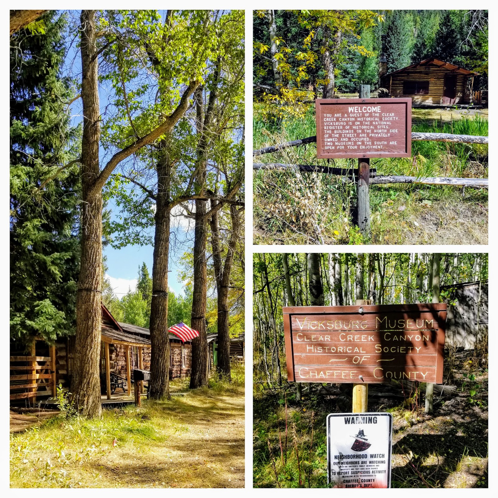
Vicksburg was founded in 1867 after prospectors from Leadville, Colorado, who were camping out in the Clear Creek Canyon lost their burros. The burros had wandered down the creek and when the miners found their pack animals, they discovered gold in the creek bed as well. More than gold, however, the surrounding area was rich in silver and copper. Early miners brought in "Balm of Gilead" (balsam poplar) trees on the backs of burros and planted them to line the main street of Vicksburg, where they still remain


Vicksburg was the second largest town in the canyon, with around 600-700 people during its peak. A museum is open here on some weekends during the summer, run by the Clear Creek Historical Society.  Many of the cabins in Vicksburg are now privately owned and seasonally occupied.


Quite a few interesting vintage mining implements and machines were on display around the cabins.


After visiting Vicksburg we continued on our drive...


...passing an area that obviously suffered an avalanche in winter at one time as many aspen trees lay broken on their sides along the side of the road.


Between Vickburg and Winfield is a small assortment of cabins for rent where more silver-boom towns once stood -- the towns of Rockdale and Silverdale. There are rustic cabins available for daily rent here. We spoke with a forest ranger who was sweeping out a cabin and she told us fishermen, hikers, mountain climbers, etc, rent the cabins all summer.


Continuing on for about five miles we reached the end of the county road and the town of Winfield.


Winfield was founded in 1861 with the first recorded silver prospecting done in 1867. Located on 120 acres at the junction of the north and south forks of Clear Creek, the town made lots of 50×100 free to anyone who desired to build there. In its prime, around 1890, some 1500 people lived in town. The silver market crash and depression in 1893 halted the mining activity in Clear Creek Canyon. There was a resumption in the early 1900s and the last ore was hauled out of the canyon by two-horse wagon in 1918.


Please click on photo to enlarge it


The history of the town is displayed in an open book in the Winfield schoolhouse window.


Two of the buildings are open as a museum during the summer, hosted by members of the Clear Creek Historical Society, while the rest are now privately owned and occupied seasonally.


There were quite a few trailheads located at the end of Winfield. The Winfield Cemetery was a quarter mile down a narrow winding road that would require high clearance 4WD.  Although 26 people are buried there, only two stone marker stones for children remained. In 2016, a descendant of one of the men buried there worked with the historical society to clean up the cemetery and place wooden crosses on the graves.  If you would like to see a local Denver news video about that effort and the story click here.


Can you imagine living such a rugged life at 10,000 feet, all because of hopes and dreams of finding riches in the surrounding mountains? The gold and the silver rush is the pioneer story of the state of Colorado and became the "boom and bust" of many a town.  To see more Colorado mining ghost towns visit my post on the Independence Pass Ghost Town--click here--and Saint Elmo Ghost Town--click here.


You can also find me on 


I'm linking this post to the following blog events:

 Mosaic Monday, All SeasonsBlue Monday, Through My Lens MondayLittle Cottage Link Party
 Hearth, and Soul Link PartyYou Are the Star Blog Hop, Inspire Me Monday,  Good Random FunNature NotesGrand SocialTravel Photos, Photo TunesHappiness Is HomemadeOver the Moon, Our World TuesdayRuby TuesdayTuesday Turn AboutTuesdays With A TwistLet's Keep In TouchWordless Wednesday on a TuesdaySay Cheese!,  Party in Your PJ'sWordless WednesdayNanahood WWOh My Heartsie Girl's Wonderful Wednesday, Your Whims WednesdayWorldless  Wednesday My Corner of the WorldWonderful Wednesday Little Things ThursdayThankful ThursdayThursday Encouraging Hearts and HomeFull Plate ThursdayFriendship FridaysFriday Features Linky Party, Skywatch Friday,   Pink SaturdaySaturday Critters
 Grammys Grid-Month Long Linky Party

Bookmark and Share

Sunday, February 23, 2020

Cottonwood Pass, the Second Highest Paved Mountain Pass in America


This is the view we had from our hotel window in Buena Vista, Colorado of a few of the Collegiate Peaks in the Sawatch Mountain Range in Central Colorado last October. We were excited to hear that the nearby Cottonwood Pass had reopened in September after being closed for three years of extensive road work.  At 12,126 feet elevation, it became the second-highest paved mountain pass in the United States after Trail Ridge Road in Rocky Mountain National Park which is at 12,183 feet elevation.  We decided to take a scenic drive over the pass all the way from Buena Vista to Crested Butte.

My husband has driven us over many Colorado mountain passes after we moved to Colorado seven years ago.  I usually sit next to him as he drives as I like to take photos.  I might be leaving some mountain passes out, but here's a list of those we driven over so far with highlighted links to a blog post about them:  Hoosier Pass, Loveland Pass, Guanella Pass, Independence Pass McClure Pass, Berthoud Pass,  Rabbit Ears Pass, Kebler Pass, Monarch Pass, Kenosha Pass, Raton Pass between New Mexico and Colorado,  Red Mountain Pass on The Million Dollar Highway, Pagosa Pass, La Veta Pass, and Vail Pass.  All are beautiful!  Cottonwood Pass is at a high elevation so it is closed for winter, usually, from November to May when there can be twenty-five feet or more of snow in the mountains!


It took three years, around $34 million, and some 90 pieces of road-building equipment to re-engineer the 31 mile Cottonwood Pass and make it a safe and beautifully scenic road--CR 306 on the Chaffee County side, CR 209 in Gunnison County.  Improvements included two 11-foot paved travel lanes with shoulders, guardrails, protection from rockfall, and additional parking areas at the summit and Denny Creek.


As we drove, we were surrounded by dense forests and mountain views...


...on an asphalt surface of the road that was smooth as glass.


From the eastern side of Cottonwood Pass, it did not take too long to reach the summit.


There is parking at the summit, trails, and a sign showing that we were traveling over the continental divide where water would feed on the eastern side to the Atlantic Ocean, and from the western side to the Pacific Ocean.


The summit vistas were magnificent!


We hiked for a while at the summit to enjoy the "top of the world" views and then continued our drive.


We continued driving on the western portion of Cottonwood Pass...


...and stopped again at Taylor Park Reservoir, at 9,500 feet elevation, to enjoy the view of the Sawatch Mountains in the distance.


We also stopped at the Taylor Park Dam to take photos.


Although autumn of 2019 was delayed by unusually warm weather, the colors here were brighter than in other areas.


The Taylor River was particularly pretty.


There were many ranches in this area around Almont,  Colorado, which was very evident by all the cattle we saw freely strolling around near the road...


...and even on the road!


They did not have a care in the world!


We finally reached Crested Butte.  I've blogged about this colorful ski town in the past--click here and hereOn this visit, it began to rain! We had lunch in town and continued on to travel back to Buena Vista but this time on Monarch Pass--my next post!


You can also find me on 


I'm linking this post to the following blog events:

 Mosaic Monday, All SeasonsBlue Monday, Through My Lens MondayLittle Cottage Link Party
 Hearth, and Soul Link PartyYou Are the Star Blog Hop, Inspire Me Monday,  Good Random FunNature NotesGrand SocialTravel Photos, Photo TunesHappiness Is HomemadeOver the Moon, Our World TuesdayRuby Tuesday, Tuesday Turn AboutTuesdays With A Twist, Let's Keep In TouchWordless Wednesday on a TuesdaySay Cheese!,  Party in Your PJ'sWordless WednesdayNanahood WWOh My Heartsie Girl's Wonderful Wednesday, Your Whims WednesdayWorldless  Wednesday My Corner of the WorldWonderful Wednesday Little Things ThursdayThankful ThursdayThursday Encouraging Hearts and HomeFull Plate ThursdayFriendship FridaysFriday Features Linky Party, Skywatch FridayFuntastic Friday,  Pink SaturdaySaturday Critters
 Grammys Grid-Month Long Linky Party


Bookmark and Share