Showing posts with label Sangre de Christo Mountains. Show all posts

Sunday, October 23, 2022

A Joyful Journey


The Colorado Sangre de Cristo Mountains

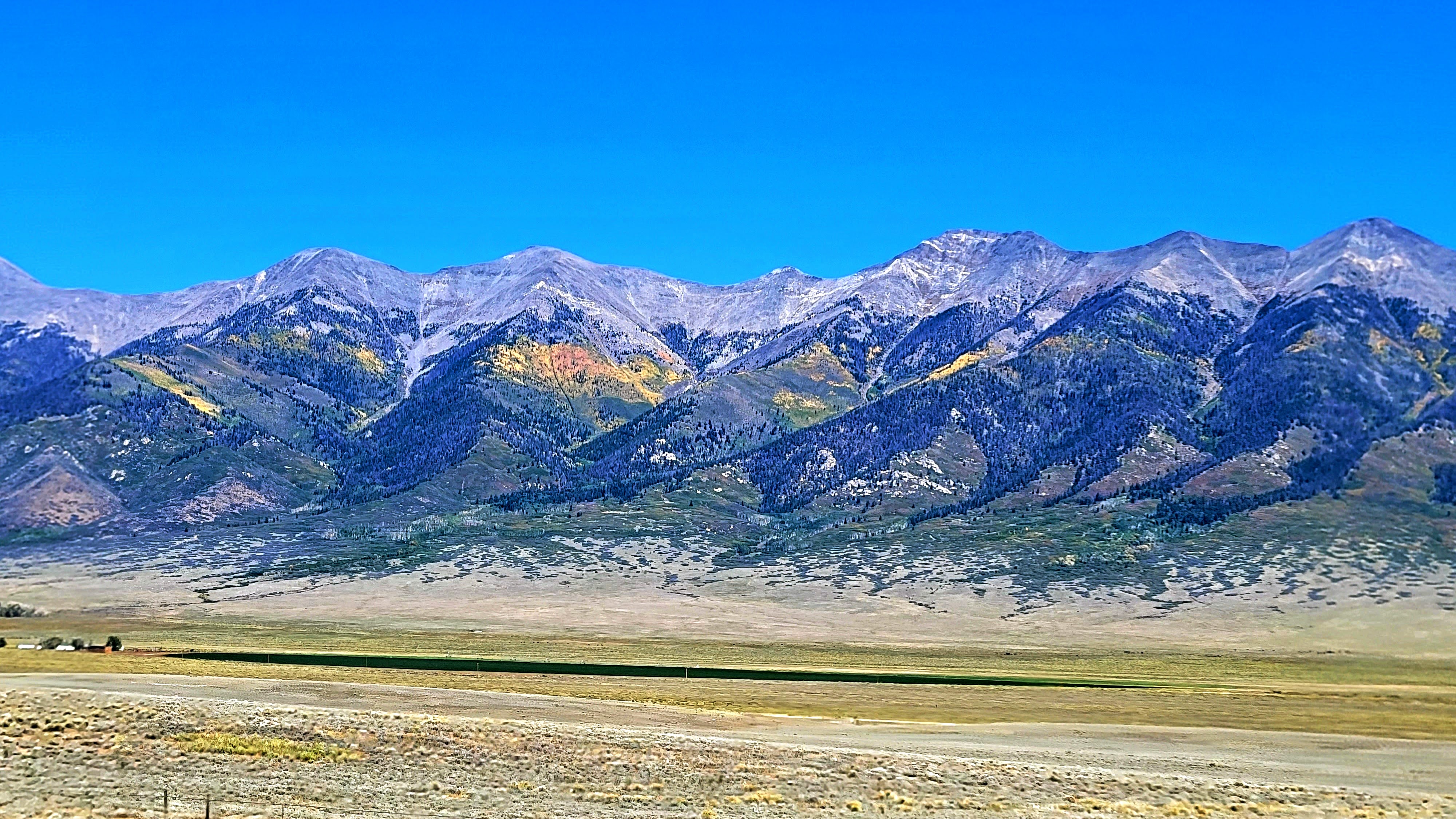
My husband and I had a wonderful anniversary trip to Southern Colorado where we hiked up part of a mountain to see Zapata Waterfall, click here. made our second visit to the Sand Dunes National Park, click here, and rode on the scenic Cumbres and Toltec Railroad to New Mexico, click here. all the while enjoying the scenic views of the 14,000 feet high Sangre De Cristo Mountain Range and the San Luis ValleyAs you can see in the photo above the aspen groves on the mountains were glowing in beautiful autumn colors!
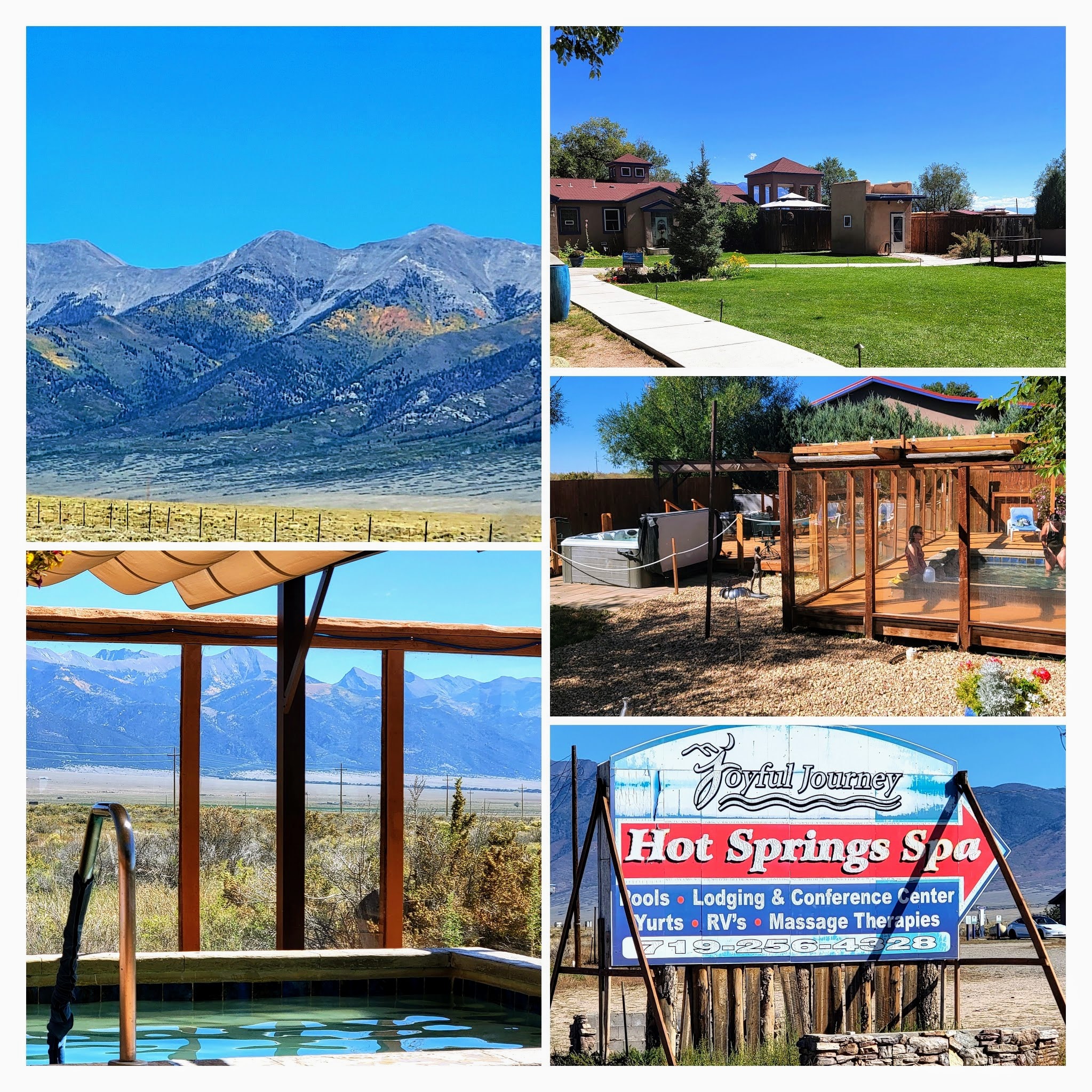


On our drive back to the Denver area, we decided to stop in at the Joyful Journey Spa for a few hours to soak in their natural mineral hot spring pools.


At an elevation of 7700 feet (2346.96 M) on the valley floor, the spa enjoys cool summers and sunny winters, as well as spectacular views of the mountain wilderness to the east. They offer lodge, casita, yurt, or tipi accommodations. They also welcome day visits.


A Hummingbird Moth we saw buzzing around a plant at the spa. 

It was wonderful to soak in the hot springs--the 108-degree pool was our favorite and so relaxing!

After 3 hours of bliss, we went back on the road...


...where we passed the Collegiate Mountain Peaks to the west...


...and then drove through the high (9,000 plus feet) alpine basin of South Park.


As we approached Kenosha Pass more aspen colors began to appear.
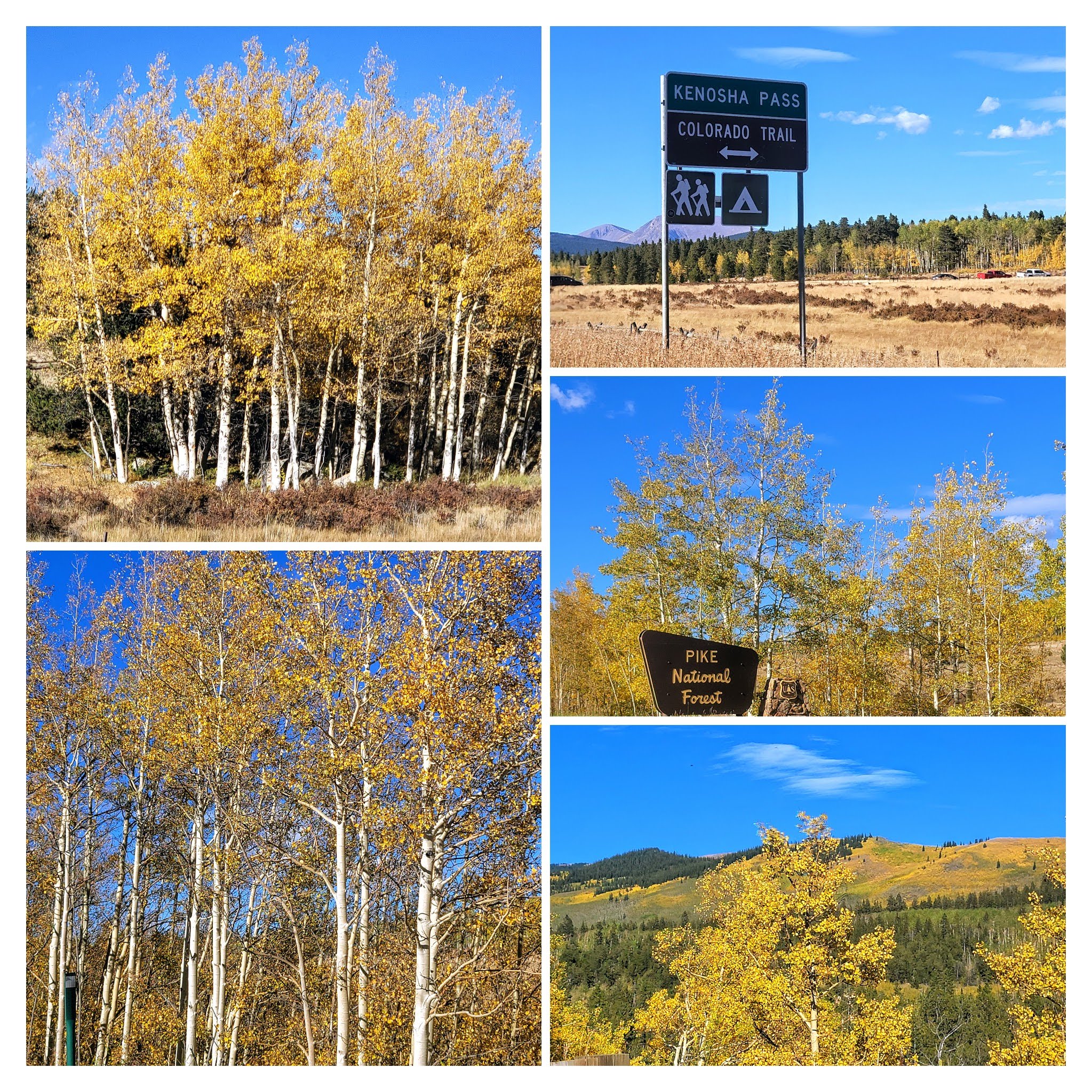


There were so many beautiful views to see as we drove by.


 Colorado is so beautiful in the fall!


We continued our drive home, thankful for another year together and another joyful anniversary celebration.


Please keep one of my favorite bloggers, Marie, of Proud Italian Cook, in your prayers! Marie and I began blogging at the same time in 2007 and she has been an inspirational source for many delicious recipes for me. Marie recently announced on Instagram that she sadly found out that she has advanced ovarian cancer and is now receiving chemotherapy and will have surgery in the future. 

Marie's son is going to compete in the 2023 Boston Marathon and was selected to help raise money for the Dana Farber Cancer Research Center in honor of his mother.  100% of every penny he raises will go towards innovative cancer research to help find a cure. His goal is to raise $26,200, which is $1000 for each of the 26.2 miles he will run on April 17th, 2023 at the Boston Marathon. Please consider supporting this cause with a tax-deductible donation. Here is the link where you can donate if you so choose: 

You can also find me on


Bookmark and Share

Monday, May 23, 2016

Mount Blanca--A Navajo Sacred Mountain


When my husband and I left the Great Sand Dune National Park (see part one blog post here, and part two blog post about these amazing sand dunes here) we traveled CO 150 South on our way towards the town of Alamosa, about 38 miles away from the park. (All photos in this post will enlarge if clicked on)


I love roadside "places of interest" or "historical markers" and often stop to see what they say. I was very glad to have stopped at this one which pointed out that the tall mountain peak in the distance was Mount Blanca.


Click on the photo to enlarge it to see what was written on the placard.


Mount Blanca is the fourth highest summit of the Rocky Mountains in Colorado. At 14,351 feet (4,374 m) it is the highest summit of the Sangre de Cristo Range.


The Navajo Native Americans called this mountain Sisnaajini (White Shell mountain). The Navajos believed it was one of the four sacred mountain peaks of the Navajo Land and a sacred mountain placed in the east, the doorway to Navajo Land because the sun rises in the east and the day begins there. They believed the First man and the First Woman, together with the Yei'i (Holy People) made the mountain with white shells, white lightning, and rain clouds and gave it positive thoughts. You can read more about the Navajo beliefs about Mt. Blanca on this link.


It was named Mount Blanca by the Spanish explorers in 1598.  By then the Navajo tribes had moved further west and the predominant Native Americans living in the area were the Utes. They entered this region with their domesticated dogs pulling their belongings, and found the San Luis Valley rich hunting grounds for bison, elk mule deer, fish, and plants. When they first saw the Spaniards riding on horses they thought the horses were "magic dogs."  When the Utes acquired horses their warriors became skilled riders and they fought off  European conquest in the San Luis Valley of Colorado until the early 19th century.


Another historical placard at this road pull-off site told about the Southwestern expedition led by Lt. Zebulon Pike in 1806-7.  He and his men were captured by the Spanish in this area and held captive in Chihuahua, Mexico for a while until they were released in 1807.


When I looked up at the high peak of Mt. Blanca I thought about the many eyes who marveled at this sight over the thousands of years before me, and the many who will gaze at it in the future. It sits as a silent and majestic sentinel of time. 


One last look at the beautiful Sangre De Cristo Mountain range in southern Colorado. It is another area that has won my heart in this great state.


Bookmark and Share 

Sunday, April 10, 2016

New Mexico--the Land of Enchantment


If you have been following along on my blog recently, you will know I've been chronicling about a trip my husband and I took in the fall, when we drove from our house in the Denver area to a family wedding in a suburb of Phoenix Arizona.  We first visited Mesa Verde National Park in SW Colorado, then the Four Corners Monument, also in SW Colorado, on through the Navajo Nation in Northern Arizona. While in Arizona we visited Saguaro National Park and the Petrified Forest National Park and the Painted Desert.  When we left the Petrified Forest National Park we headed right into the state of New Mexico by Interstate 40. It was late afternoon, and we knew we had many miles to drive before we reached the hotel where we had reservations in Las Vegas, New Mexico, for the night, which would be about halfway home.
(All photos and collages in this post will enlarge if clicked on)


New Mexico's motto is "The Land of Enchantment," and it is easy to see why. The landscapes we passed along the road were spectacular!


The late afternoon sun gave the landscape a beautiful glow.


It seemed as if we could see for hundreds of miles all around us, and we watched as rain clouds gathered before us.


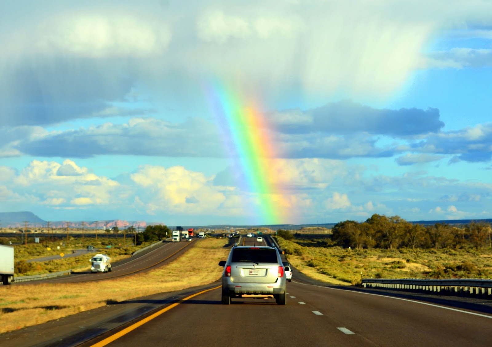
Finally, it began to rain in one area while a big beautiful rainbow formed in the sky in another area!


Mother Nature put on a beautiful show while we drove...


...and the rainbow followed us for many miles.


The rain stopped, but the large cumulus clouds remained on the horizon.


Such glorious scenery...


...we knew we would be back one day to explore more of New Mexico.


The sun began to set and it lit the sky with gold and crimson. 


As we approached Albuquerque, New Mexico, we drove NE onto Interstate 25, where we saw this tour bus in a gas station rest stop. Unfortunately, that is all we saw for the rest of the night, as the sunset and we drove the rest of the miles in darkness.


The next morning we checked out of our hotel and took a ride to the nearby Las Vegas National Wildlife Refuge. This 4,200-acre refuge and conservation area promotes the protection of private working ranches via conservation easements. Las Vegas is Spanish for "the meadows," and this is the perfect place to personify much of what this area topography consists of, both short and long grass prairie. The refuge has nature trails, scenic drives and an overlook observation deck to observe migrating birds and land animals.  If you click on to enlarge the collage above you can read more about the preserve and the animals that depend on the land. It was raining when we visited the preserve so we did not walk any of the trails, nor did I get any good photos of the wildlife, but it was still an interesting place to visit.


We also took a drive through the town of Las Vegas, New Mexico, that was established in 1835 by the Mexican government. During the Mexican America War in 1846, Stephan W. Kearney delivered an address at the Plaza of Las Vegas, claiming New Mexico for the United States.  Las Vegas became part of the Santa Fe Trail and its popularity grew,  A railroad came to the town in 1880 and the town continued to grow. Along with the development, however, came many new residents some of which had an unsavory element of the "wild west."  Notables were Doc Holliday, Jesse James, Billy the Kid, Wyatt Earp, Mysterious Dave Mather, and Hoodoo Brown.


Click on the photo of the placard above which shows a map of the Santa Fe Trail, that led from Independence, Missouri to Santa Fe, New Mexico, and describes its significance to the American West.


Just by serendipity, my husband and I happened to stop for gas for our car at the last grand landmark on the Santa Fe Trail called Wagon Mound.  The nearby butte was said to resemble a Conestoga Wagon, very much like the early settlers used to carry all their belongings and families west.


Wagon Mound butte was the last great landmark on the westward journey across the plains of northeastern New Mexico, and the guidepost seen by all travelers on the High Plains section of the Cimarron Cutoff of the Santa Fe Trail.  Click on the placard above to read more about this spot.


We continued driving north through the plains area of New Mexico.


There was not much to see in this area besides the beautiful clouds and sky.


We reached the border between New Mexico...


....and entered our home state of Colorado, where we would travel over more of the Santa Fe Trail over Raton Pass.


Raton Pass, at 7834 feet elevation, is a mountain pass and also a National Historic Landmark. The pass is located on the eastern side of the Sangre de Christo Mountains between Trinidad, Colorado and Raton, New Mexico, approximately 100 miles northeast of Santa Fe. The pass crosses the line of volcanic mesas that extend east.


If you click on the photos above and below you can read more about the pass and a brief history of the nearby town of Trinidad, Colorado.


Trinidad became a large coal mining town, and also became a melting pot of many ethnicities due to the abundance of mining jobs.  The coal mines closed over the years, but since the 1980s companies have been drilling gas wells here to extract coal bed methane gas.


Knowing we were a couple hundred miles from home we did not do any more stops along the way. As much as we love to travel, it is always good to return to the familiarity of home.


As we pulled into our driveway, we were welcomed home by a deer in our next-door neighbor's yard. I'm sure she also had a nice time eating my flowers while we were away--smile.  It was good to be back, with many happy memories and photos, that I have been delighted to share with all of you!


Bookmark and Share