Showing posts with label Famous People from the American West. Show all posts

Monday, March 13, 2017

Manitou Springs, Colorado


Manitou Springs, Colorado, is a small and charming town minutes away from Colorado Springs, and nestled between Garden of the Gods Park and America's most famous mountain, Pikes Peak. The word "Manitou," is a Native American word for "great spirit." Ute, Cheyenne and other Native American tribes attributed the natural mineral springs they found in the area as sacred, as a place of peace and healing.  General William Jackson Palmer, a western railroad magnate,  and Dr. William Abraham Bell founded the town of Manitou Springs in 1872, intending the town to be a "scenic health resort."

We visited the town in the fall of 2016, where most of these photos originate, and again recently when we had some family members visiting us--see that post on this link, and I thought I'd tell you more about this interesting and historical town.

(All photos, and photo collages, will enlarge when clicked on)


This boulder near the center of town marks the eastern end of the Ute Pass Trail, one of the oldest Native American Trails in the United States. The Ute Pass Trail runs along the north side of Pikes Peak. Native Americans first paved the trail on their travel over the the Ute Pass, and then in the 1860's it became a wagon road.  Now it is used for hiking, biking, running or horseback riding. The trail head is located near the Pikes Peak Cog Railroad parking lot.

 Please click on to enlarge

As you can see by the photos above there were many natural mineral springs located in the area that the ancient peoples and Native Americans used for eons. These waters became known as "healing waters" and during the Victorian era when diseases like tuberculosis was rampart people sought out natural cures. Mineral water was felt to cure liver, kidney and digestive aliments. 

Please click on to enlarge

The town of Manitou Springs was built up around these springs and became a resort area with bath houses, a mineral water bottling plant and hotels and spas.  If you enlarge the collage above you can read where the mineral water originates from and more about the town history.


Manitou Springs has eleven naturally carbonated mineral spring drinking fountains throughout the historic district, and eight of these springs are open to the public to sample for free. Each one tastes a little different from the next. You can get a map of all the mineral spring fountain locations at the Manitou Springs Visitor Center, located at 354 Manitou Avenue. They will also provide you with a plastic cup if you ask for one. 
My husband and I enjoyed searching out all the springs and sampling small sips of the water. Our favorite was Seven Minute Spring, located in a park near the beginning of town.  We felt it taste similar to club soda. Our least favorite was the Iron Geyser, which is closest to the mountain along Ruxton Creek, and definitely has a strong metallic iron taste. We could see why it was called "the strongest of tonics" at one time! 

The other mineral fountains are the Shoshone, the Navajo, the Cheyenne, the Wheeler, the Stratton, and the Twin.

If you click on the highlighter names of the fountains it will bring you to the Mineral Springs Foundation page that will describe the characteristics of each spring and its location.


The historic center of Manitou Spring is filled with interesting and picturesque Victorian era architecture


I particularly liked this baby blue building, on Canon Avenue, that was built in 1887 by Dr Isaac Davis to house his pharmacy. It is now privately owned as an artist's studio.


 Please click on photo to enlarge

The Wheeler Town Clock was donated by Jerome Wheeler in 1889 for the opening of the Manitou Mineral Water Bottling Company that existed at that time. Click on the photo to read more about this historical clock.

 Please click on to enlarge

The Nolan House was built by John Nolan in 1890.  Nolan was the owner of the Colorado Springs Lumber Company at the time and also owned several saloons and a Cripple Creek gambling hall. Click on the photo to read more about the house.

Please click on to enlarge

The Cliff House was built in 1874 by two Canadian investors and was the second largest hotel in Manitou Springs at the time.  It was visited by many famous people over time--click on the photo to read its history.  This Queen Anne style hotel has been fully renovated and is still used as a hotel and event center..


My husband and I dined in the elegant  Cliff House Dining Room for a delicious lunch.


A another step back into time is the Miramont Castle Museum. This incredible Victorian style castle has over 30 rooms and nine styles of architecture. Built in the late 1890's by a French priest, Jean Baptiste Francolon, who came to Manitou Springs in hopes of restoring his ailing health. His mother and her servants joined him soon after. The family came from wealth and the mansion was filled with artwork, fine furnishings and tapestries. The Francolons left for France in 1900, never to return. In 1907 the Sisters of Mercy purchased the mansion to use it as a tuberculosis sanitarium for twenty years.  In 1928 it became a boarding house and vacation retreat for the wealthy until 1946 when it became privately owned. In 1976 the Manitou Springs Historical Society purchased the mansion as their headquarters and began renovations.  It now conducts tours of the house, many events throughout the year, and hosts a tearoom for High Tea and light Victorian Tea, reservations required.


The historic district of town is lined with many unique shops, art galleries and trading posts filled with handcrafted Native American treasures.  Manitou Springs is home to many artists, and attracts a young bohemian crowd, especially during the summer months.


Another attraction in town that draws athletes, and the physically fit who like a challenges, is the Manitou Incline, seen looming over the main street in the foothill above.


A close up of the incline.

The Manitou Incline is the remains of a former narrow gauge funicular railway, whose tracks washed out during a rock slide in 1990. It is now used as a fitness challenge trail, as it has steep grades of 45% to 68%, and gains over 2,000 feet (610 m) of elevation in less than one mile. It recently went through renovations from August, 2016 to December, 2017 and is now open again.  


Do you think you are up to the challenge of hiking so many steps at such a steep climb?


The Manitou Springs Penny Arcade is located at 930 Manitou Avenue in the middle of town, and is one of the oldest and largest amusement arcades west of the Mississippi! With over 250 machines dating back to actual penny pinball machines to modern video game machines, skeeball, and rides for small children, this area has been a favorite attraction for many, many years.


Opened in 1891, the Manitou and Pikes Peak Cog Railroad, is the highest cog railroad in the world! It is located at 515 Ruxton Avenue in Manitou Springs.  You can purchase tickets to ride the railroad--reservations required a few days in advance--most months of  the year, to visit the top of Pikes Peak, at an elevation of 14,115 feet, and back.  A train runs every 80 minutes, with an average grade of 12%, and at times reaches a grade of 24%.  Once on top of the mountain you will be able to see five states on a clear day! 
When my younger brother visited Colorado a couple years ago in October we took a ride together up the cog railroad and really enjoyed the views!  To see my blog post about driving up Pikes Peak in the summer, click here.  The panorama from the top of the mountain is remarkable!


Some famous people from Manitou Springs past.


Sadly, in 2012, the Waldo Canyon Fire occurred near Colorado Springs and Manitou Springs and Woodland Park. It destroyed 346 houses, killed two people, and burned 18,247 acres (28.511 sq miles) in the Pike National Forest.  The burn area created "burn scar flood" in 2013 as rain water increased flow in six waterways and picked up mud and debris that caused damage to many homes and businesses in Manitou Springs. Much mitigation was done and the resilient town is thriving again.  It is definitely a wonderful place to visit, and to stay, to enjoy many local attractions.  Come and sample the mineral water, climb the incline, shop in the quaint stores and dine in one of the many restaurants.  You will have a memorable time!


I'm linking this post to the following blog events:

Thank you to all the blog hosts!


Bookmark and Share

Sunday, January 15, 2017

Bent's Old Fort National Historic Site on the Santa Fe Trail


One of the most evocative places to visit for history buffs of the Old West is Bent's Old Fort National Historic Site located on the plains of SE Colorado, just outside the town of La Junta. This reconstructed trading post was the last United States outpost for travelers before they would cross the Arkansas River and enter what was then a territory of Mexico, now New Mexico. The fort was originally built in 1833-34 by brothers Charles and William Bent, and Ceran St Vrain, as a trading post for the Native American fur trade.  Finding success the partners soon expanded and built other trading posts to the north and south and stores in Santa Fe and Taos.

Map Source

Bent's Fort soon became an important part of the Santa Fe Trail. The "Father of the Santa Fe Trail" was Captain William Becknell. In 1821 the land beyond Missouri was a vast uncharted region known only for its vast bison herds and Native American inhabitants. When Mexico won its independence from Spain in 1821, trade between Santa Fe and the United States became a possibility, and Captain Becknell was determined to cross the hostile territory to do trade, blazing a path that would become known as the Santa Fe Trail. Soon, many wagon trains were using the trail to head to the southwest. Two passages soon developed, one called the Cimarron Cutoff and the other the Mountain Branch over Raton Pass--see map above. Bent's Fort became an important stop for those on the Mountain Branch of the trail.


Travelers, traders, trappers, the US Army, and the Cheyenne and Arapaho tribes came together at Bent's Fort to rest, eat, trade and buy supplies and repair their wagons.  The largest trade with the Native Americans was for bison hides in exchange for the white man's goods. The famous Western Scout, Kit Carson, was a hunter for the fort from 1831 to 1842.  The explorer John C. Fremont used the fort as both a staging area and replenishment junction for his expeditions. During the Mexican-American War, in 1846, the fort became a staging area for Colonel Stephen Watts Kearny's "Army of the West." Kearny went on to seize New Mexico for the United States, and seventeen hundred army men and volunteers used the fort as the rendezvous point for the invasion.


Bent's Fort is described as having been a structure 180 feet long and 135 feet wide, built of adobe bricks. The walls were 15 feet in height and four feet thick. It was the strongest post at that time west of Fort Leavenworth in Kansas.


Some of the other principals in the history of Bent's Fort as displayed in a placard in the History Colorado Center exhibit. Please click on to enlarge this photo, and any other photo in this post, to enlarge them to see details.

Click on to enlarge

As one approaches Bent's Fort there is a gravestone of a stagecoach driver, Edward Dorris, who died in 1865 and is buried along with approximately 12 others in graves in a burial ground outside the fort. The Santa Fe Trail was always a perilous route and many perished along the route. On a prior blog post, about New Mexico, I showed one of the last grand landmark stops along the Santa Fe Trail, called Wagon Mound, where many settlers were attacked by Native Americans who were angry that their hunting grounds were being invaded and destroyed. Click here to read that post. That post also shows Raton Pass, which was the mountain pass the Santa Fe Trail traveled over.


Bent's Fort entrance is open to a large plaza surrounded on all sides by two level walls with staircases leading up to them ....


...and shaded walkways  along all the corridors leading into the varied rooms.


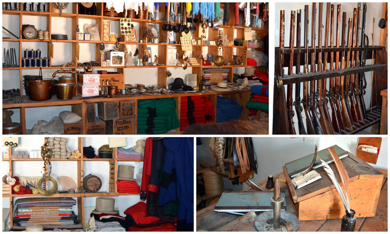
Primarily a trading post, Bent's Fort sold and traded goods in their general store. It was stocked with items such as calico fabric, blankets, cooking utensils, tobacco, muskets, gun powder, knives, buckets, medicines, beads, clay pipes, coffee, chocolate, corn, animal feed, writing material, and so on.


The fort was also operated by people of many nationalities and vocations, including blacksmiths, trappers, carpenters, wheelwrights, gunsmiths, cooks, cattle herders, clerks, etc.,  who would offer their services for a fee to visitors to the fort, 


The kitchen was staffed with cooks, including a slave of Charles Bent, Charlotte Green, who was famous for her pumpkin pies and flapjacks.


The ground level rooms also consisted of meeting rooms, and offices


As the resident Manager, William Bent oversaw all trade at the fort. He occupied private quarters in the fort, but also lived with his Cheyenne wife and family in their village as well. 


Bent's Old Fort often has days that feature costumed living history interpreters that provide guided tours and demonstrations, but my husband and I visited between tours and did a self guided tour instead, with literature provided by the staff. You can check the park web site for a calendar of events and tours held at the park on this link.


View of the fort entrance from the second floor...


...and from the other side of the ramparts.


It was interesting to see more of the re-construction of the fort that the National Park Services completed in 1976, as part of the United States Bicentennial Celebration, as well as the state of Colorado's Centennial Celebration. 


Most of the rooms upstairs were used for boarding, and were re-furnished in period style. 


There was even a billiard room upstairs. Billiards, card games, and chess and checkers were played to ease the long nights and days and help the fort's employees deal with boredom and home sickness.


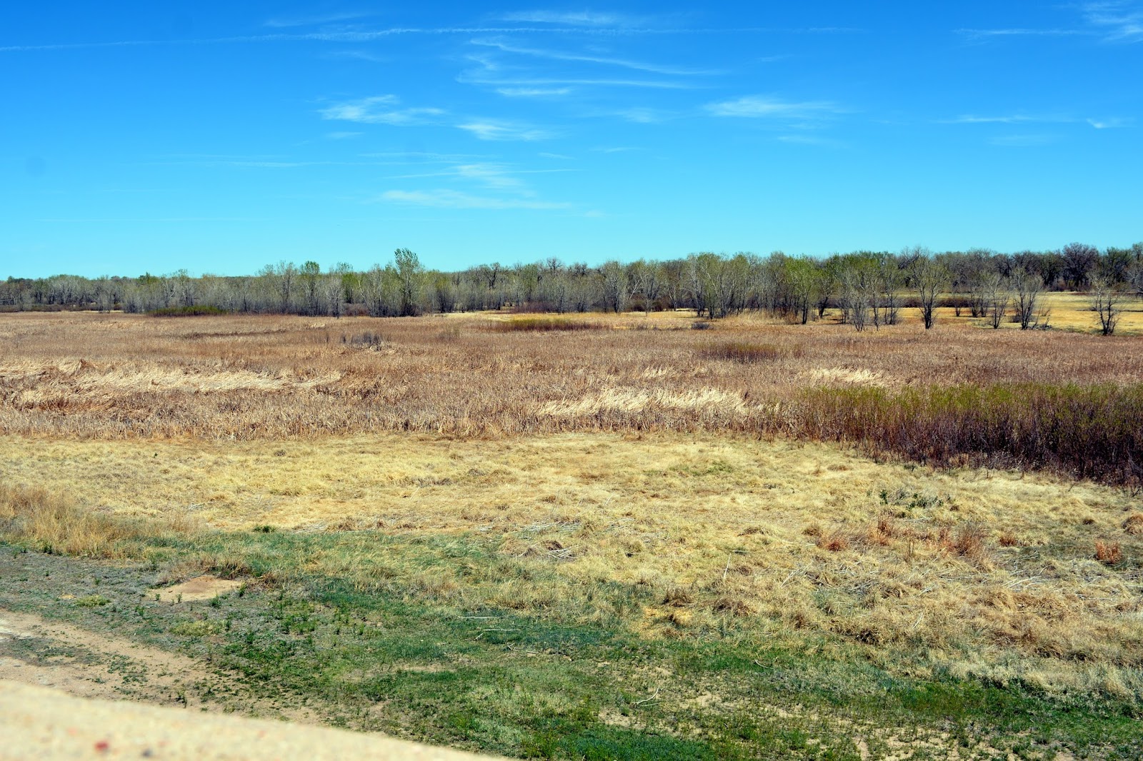
A view of the Colorado plains from the roof top of the fort.


Often referred to as the "Castle on the Plains," Bent's Fort also had cannons for reinforcement.  The fort was never attacked, however, and the Bents worked hard to broker peaceful relations with all that they came in contact with.

More informational placards from the History Colorado Center. Click on to enlarge

After the war with Mexico, Charles Bent became the Governor of New Mexico, but on January 19, 1847, revolting Mexican and Pueblo Indians murdered him and other Americans in Taos.
The US government never paid the Bents compensation for using the fort for housing and supplying Kearny's troops during the Mexican American War. When there was a cholera epidemic and increasing unrest among southern Native American tribes who raided the Santa Fe Trail wagon trains, business declined at Bent's Fort and it fell on hard times. William Bent offered to sell the fort to the US Army in 1849, but they declined the offer. So a frustrated Bent moved his operations out and set fire to the fort, and abandoned it.
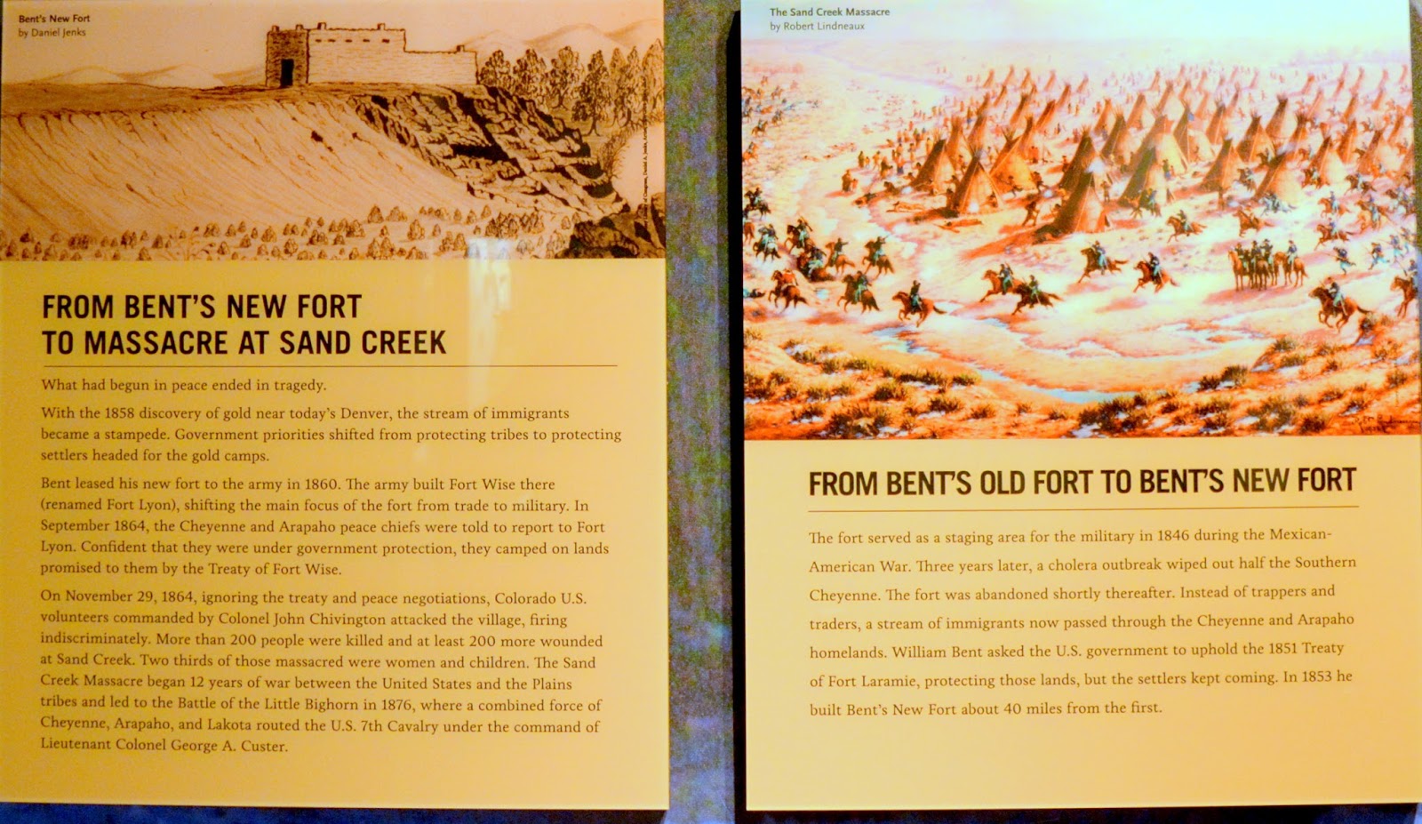
William Bent then built a new fort at the Arkansas River in 1853, known then as Big Timbers, but the glory days of trade were over, and it was not successful.  Bent leased this fort to the Army in 1860, which then constructed Fort Wise--later renamed Lyons-- nearby.  Ob November 29, 1864, Colonel John Chivington marched towards the Cheyenne Sand Creek Reservation, to destroy the native American's camped there, lead by the peace chief Black Kettle. Chivington posted a guard on William bent to prevent him from warning the Cheyenne leader and his people. You can read the story of the Sand Creek Massacre that occurred nearby in the placards above,  or on my blog post --here--about that event. William Bent died heartbroken in  Westport, Kansas in 1869.


Although most of Bent's Fort had been abandoned it was still used over time as stagecoach station and later as cattle corrals. In the 1950's the Colorado State Historical Society acquired the Bent's Old Fort and arranged for archaeological investigation to determine the fort's outlines. It was declared a National Historic Landmark in 1960.


Exhibit at the History Colorado Center of artifacts found at Bent's Old Fort.

More archaeological excavations occurred after it became part of the National Park Service system and the park was reconstructed in 1976 with the help from these artifacts, diaries sketches and paintings.  

Bent's Old Fort National Historic Site preserves for the future the remarkable history of the fort as a place of early trade, it's role on the historic Santa Fe Trail, as well as its role in Western Expansion. It is a fascinating place to visit to learn about the Traders, Tribes and Travelers of the old west!


I'm linking this post to the following blog events:

Thank you to all the blog hosts!


Bookmark and Share

Sunday, March 17, 2013

Lookout Mountain and Buffalo Bill


In a prior post about the Miller Coors Brewery in Golden, Colorado, I promised I'd show you a trip my husband and I, and one of his New York Co-workers took up to the top of Lookout Mountain. If you look closely you can see the mountain in the distance on the photo above, on an uncharacteristically overcast day in Colorado.

With an elevation of 7, 581 feet, Lookout Mountain is one of the larger foothills which overlooks Golden, Colorado.  On a clear day, the Denver metropolitan area can be seen clearly from the mountain 12 miles to the east.


From the town of Golden we drove onto 19th Street, which briefly goes through a residential neighborhood, and then leads to a section Lariat Loop Byway to the top of the mountain. The Lariat Loop Byway is a 40-mile route built-in 1914. This byway is a combination of two historic routes: the Lariat Trail Scenic Mountain Drive ascending Lookout Mountain and the Bear Creek Canyon Scenic Mountain Drive. In combination, these routes were part of several of the “scenic circles” developed and promoted by Denver in the 1915-1920s to help Coloradans experience the mountains in proximity to the Denver Metropolitan area. These roadways were designated to the National Register of Historic Places in 1976. A video about the interesting sights that can be seen along this byway can be viewed at this link.

Two-Stone Pillars in the photo above mark the northern entrance to the Denver Mountain Parks and the Lariat Trail.


As we begin the drive I could see threatening clouds on the horizon, but the view of Golden was amazing. A part of the Colorado School of Mines football field can be seen at the bottom of the photo. The Colorado School of Mines is a distinguished engineering and applied science university.


Even though the clouds hung low, the views were beautiful.


We actually passed through the clouds at this elevation...


...and it began to snow!


Our road view changed from foggy...


...and misty...


...to a snowy white-out!  it was too late to turn back, we had to keep going.


We finally reached our destination at the top of the mountain...Buffalo Bill's Grave and Museum.


As you can see from the photo collage above, the parking lot and look out to the valley had hardly any visibility and the walk up to the gravesite was slippery, but we continued to walk up anyway.


Buffalo Bill's grave and that of his wife were covered with snow.  It had a stone marker and the gravesite was surrounded by an iron fence,


Some close-ups of the plaques on the gravestone. Click on the photo above to make it larger, and then again when it opens, so that you can read the inscriptions.

William F. "Buffalo Bill" Cody (1846 -1917) was an American soldier, bison hunter, and showman. He was born in the Iowa Territory (now the U.S. state of Iowa), in Le Claire, but lived several years in Canada before his family moved to the Kansas Territory. Buffalo Bill received the Medal of Honor in 1872 for service to the US Army as a scout. One of the most colorful figures of the American Old West, Buffalo Bill became famous for the shows he organized with cowboy themes, which he toured in Great Britain and Europe as well as the United States.


The Pahaska Tepee Cafe and Gift Shop was a welcoming place near the gravesite to buy a cup of coffee and warm up a little. The building was named "Pahaska Tepee" after Cody's hunting lodge of the same name outside of Yellowstone Park. Pahaska was a native American nickname for Cody, that meant "longhair."


Unfortunately, the Buffalo Bill Museum was closed on Mondays, so I bought this fascinating retrospective book about the museum collection in the gift shop.  It is also a biography of Buffalo Bill called: Buffalo Bill: Scout, Showman, Visionary written by the museum director, Steve Friesen.

Information about the book from its website:

"William F. "Buffalo Bill" Cody was America's first celebrity. He lived during a time of great geographic and technological expansion, a time when American mass media became dominant. Cody was there at every step, the right person at the right place at the right time. It was through those brilliant efforts that Cody the man became Buffalo Bill the celebrity and, eventually, Buffalo Bill the legend."


I enjoyed learning more about Buffalo Bill, beyond the myths and legends I knew about him. He was the ultimate frontiersman and showman and brought the lure of the American West to all parts of America and Europe through his "Wild West" exhibitions. To watch a fascinating historical video about Buffalo Bill, with scenes from his life and his Wild West show go to this link on the Biography.com website.

Someday I'll return to Lookout Mountain on a more scenic day, and drive more of the Lariat Loop Byway.  There is quite a bit to see and do and I know you'll also enjoy learning more about this area of the front range of Colorado!


Bookmark and Share