Showing posts with label Canada. Show all posts

Sunday, July 14, 2024

Peggy's Cove, Halifax, Nova Scotia Canada


 Nova Scotia is home to over 160 historic lighthouses, and these majestic beacons can be found throughout the province. Some of the lighthouses are world-famous! One of the most well-known lighthouses in Nova Scotia is Peggy's Cove Lighthouse, also known as Peggy's Point Lighthouse. It may be the most photographed lighthouse in Canada. It is located in the quaint fishing village of Peggy’s Cove along the South Shore, Peggy’s Point Lighthouse was built in 1915.


We visited Peggy's Cove as a half-day excursion we booked on our recent East Coast Princess Cruise.  It was the second time we saw this charming lighthouse as we visited it twenty years ago when we took our very first cruise to celebrate our 30th wedding anniversary on the Queen Mary 2 during her maiden year.


It was wonderful to visit again and see this iconic lighthouse looking very much the same with the addition of a large network of viewing boardwalks surrounding it for safety.  The rock outcrop the lighthouse sits on can get very slippery and giant rogue waves can arrive, even on calm sunny days, which can be very dangerous.   Our excursion guide told us that over two hundred cruise ships visit Halifax each year and they expect that number to increase with time, so during the slow tourist time during the Covid pandemic, Canada invested in building the boardwalks to make the area safer for tourists.


Peggy’s Cove is famous for its picturesque, typically East-Coast profile, with houses perched along a narrow inlet and on wave-washed boulders facing the Atlantic.   


Despite being designated as a preservation area, it is still an active fishing and lobster trapping community with families who have lived there for many generations.

Below are two interesting informational placards about the fishing industry in the area....click on each photo two times to fully enlarge them to read the information:


This placard below describes how the natural beauty of Peggy's Cove has attracted many artists and photographers over the years:


One such artist who became famous as a painter, sculptor and illustrator was William E. DeGarthe. He was born in Finland in 1907 and immigrated to Canada when he was 19 years old. He apprenticed under Stanley Royle in Sackville, New Brunswick, while studying at Mount Allison University. William Edward DeGarthe paintings were of Peggy's Cove and the villagers and small coastal towns around it.  Degarthe's Peggys Cove home and studio has been transformed into the William E. deGarthe Gallery where 65 of his paintings and sculptures are on permanent exhibition. It is open from May 1 until October 31 each year.


An informational placard on the side of the DeGarthe gallery--click on to enlarge.


In the late 1970s, deGarthe began a ten-year project to sculpt a "lasting monument to Nova Scotia fishermen" on a 30 m (100 ft) granite outcropping behind his Peggy's Cove Home. In 1976 deGarthe invited one of his students, J. Rene Barrette (Lt. Col. Retd) to help him with the sculpture. They worked together for 5 years. The project was about 80-per cent complete when the artist died in 1983


Some close-ups of the sculpture.

The work depicts thirty-two fishermen and their wives and children enveloped by the wings of the guardian angel St. Elmo. It also features the image of Peggy, a legendary late-18th century shipwreck survivor deGarthe believed gave her name to the village. DeGarthe bequeathed the sculpture to the province of Nova Scotia and it can be viewed in a park located behind his former home/


Degarthe's ashes are interred inside the sculpture.


A last look at the picturesque village and lighthouse. We were happy to visit Peggy's Cove again and learn more about it!

My life lately:
I hope everyone is having an enjoyable summer! We have been busy as we helped move our community's historical society's large historical archive collection from one building to another. My husband and I have also been involved in a project with other volunteers to digitalize the many historical files and photographs for preservation purposes. We have many sites in our area on the National Register of Historic Places, so the work is very interesting  We also lost two dear local friends recently-- one was expected but one was not.  We hold our good memories of them both in our hearts. Cherish each day to the fullest!

Saturday, November 9, 2019

Skagway, Alaska and the Yukon, Canada


Skagway, Alaska, is located at the northernmost point of the Inside Passage in Southeast Alaska. It's home to many gold-rush-era buildings that have been preserved as part of the Klondike Gold Rush National Historical Park. The streets are lined with wooden boardwalks and colorful, restored buildings, looking much as they did over 100 years ago. When our cruise ship docked in the Skagway port for the day we had an opportunity to walk around this charming little touristy town before our bus excursion into the Yukon region of Canada began.


Double click on the map to enlarge to its fullest to see the gold rush trails in the small box.


The Klondike Gold Rush began in 1896 when gold was found in the Klondike region of Canada's Yukon Territory. On July 29, 1897, the steamer Queen brought the first boatload of prospectors to Skagway. More ships brought thousands of hopeful miners, called "Stampeders," into the new towns of Skagway and Dyea, where they prepared for the 600-mile journey to the goldfields in the Yukon region of Canada.


To prevent mass starvation in the remote Yukon Territory, the Canadian government required every stampeder to bring a year's supply of goods with him before crossing the border. Chilkoot Pass, a high mountain pass through the Boundary Ranges of the Coast Mountains in the U.S. state of Alaska and British Columbia, Canada, was the first route the Stampeders used, and as you can see in the vintage photos above, the men carried their heavy loads of supplies on their backs. As the gold rush progressed, three aerial tramways and several surface hoists were constructed and operated briefly over the pass. 


When the White Pass and Yukon Route Railroad was built and connected Skagway with Whitehorse, Canada, the Chilkoot Pass route fell out of favor with miners.


A view of the White Pass and Yukon Route Railroad from the Klondike Highway. The White Pass and Yukon Route Railroad runs past the famously steep Chilkoot Trail and offers sweeping mountain views during its climb toward Canada. 


As we walked around Skagway we saw many tourist souvenir type shops, but we did learn of a few historic places. The "haunted" Golden North Hotel--seen in the center of the top collage photo above--is the oldest hotel in Alaska. We also learned that the Arctic Brotherhood Hall--the building on the extreme right in the lower photo above-- was built in 1899, and has more than 8,883 driftwood sticks nailed to its facade, is thought to be the most photographed building in Alaska! The club was formed by a group of gold prospectors who arrived in Skagway from the City of Seattle ocean steamer, to set off for the Klondike gold fields seeking fortune. The club was a place for miners to connect and look out for each other.


The Red Onion Saloon was built in 1897 and operated as a saloon, dance hall and one of the finest bordellos in Skagway. It is now a bar, restaurant, and museum, with also a "haunted" history. Tours of the saloon by "good time girls" are available for $10

When on a cruise, one has to plan day excursions in advance, especially if you don't want to be closed out of a popular one. When my husband and I looked at the available excursions for our ship's day stop in Skagway, Alaska, we decided to pick an eight-hour bus ride tour of the Canadian Yukon, instead of staying in town or riding the White Pass Railroad.


I was excited to see this legendary part of Canada--the historic land of the Klondike Gold Rush, the Royal Canadian Mounted Police, and the land of rugged natural beauty and wilderness.  Another influence for me was my love of the book Mrs. Mike that I read as a young adult.  I remembered it was the most thrilling and poignant book I ever read at that time of my life, and it made me hope to be able to see the wilderness of western Canada someday. I had visited Waterton-Glacier International Peace Park in Alberta, Canada a few years ago--click here to read that post--and now I was excited to see a small part of the Yukon.


We began the bus ride in Skagway to Carcross, on the Klondike Highway.  The highway links the Alaskan coastal town of Skagway to Yukon's Dawson City. Its route somewhat parallels the route used by prospectors in the 1898 Klondike Gold Rush.


The weather was overcast and misty. That seems to be fairly common for Alaska in the month of June.


We passed waterfalls that ran down the entire mountain...


...and emptied into the beautiful winding river.


At one point we're excited to see a moose running across the river! Can you spy him in the photos above?  Click on the collage to enlarge it for a bigger view.


We saw beautiful vistas during the drive ...


... of White Pass, British Columbia, the Yukon, and Lake Bennett. Our bus driver, who was also our tour guide, was very informative and told us interesting stories about the Yukon as she drove and at each stop along the way.  Bove Island in Tagish Lake can be seen in the photo above.


We stopped at the Carcross DesertIt is often considered the smallest desert in the world. The Carcross Desert measures approximately 1 square mile (2.6 km2), or 640 acres. 


We also made a stop at Emerald Lake.  The color derives from light reflecting off white deposits of marl, a mixture of clay and calcium carbonate, at the bottom of the shallow waters. The high concentration of calcium carbonate in the water here comes from limestone gravels eroded from the nearby mountains and deposited here 14,000 years ago by the glaciers of the last ice age.


We visited the Yukon Suspension Bridgewhich is 200 ft (60.96 meters) long and stretches 57 ft (17.36 meters) over raging rapids on the Tutshi River Canyon.


Along with the spectacular views at this location, there were trails, an outdoor museum, a restaurant, and shops located at the bridge site.


My husband fit right in with this vintage photo of Royal Canadian Mounties that was part of the outdoor museum! The North-West Mounted Police maintained peace and order in the Yukon and protected the gold seekers from themselves.


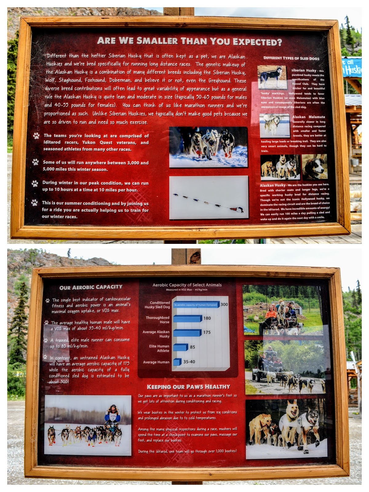
Our next stop was at the Caribou Crossing Trading Post where there was an Alaskan Husky Dog training camp! These are the breed of dogs that are trained to pull dog sleds over the heavy snows of winter, and also to race in the Iditarod.


There were adorable new puppies and star athlete dogs to view!


Please double click on the photo to enlarge to read

Some interesting information about Alaskan Husky Dogs on these placards.


The Royal Canadian Mounted Police (RCMP) Museum is also located at this site. It commemorates the role that the Mounties played in the developing Yukon with interesting exhibits.


We learned what it took to manage this vast and environmentally unforgiving terrain. It certainly reminded me of what I read in my favorite novel, Mrs. Mike.


Taxidermy creatures of Yukon animals in realistic poses, both from the past and the present, were also on display.  These were just a small portion of what we saw.


The scenery at the trading post was also very impressive!


Next, we drove into the town of Carcross, also know as Caribou Crossing


We unboarded the bus at Carcross Commons where 18 artisans’ boutiques, a restaurant, a coffee shop, and a playground are located. The Commons also hosts the Skookum Jim’s House, which is currently home for Parks Canada – Chilkoot office and a Mac Bride Museum exhibition about the Gold Rush.


Examples of Tagish First Nation (CTFN) totems.  Totem poles have deep meaning to the Carcross-Tagish people, representing clan stories and accomplishments.

 Please click on to enlarge photo


St. Saviour’s Anglican Church was founded in 1904. In 1903, St. Saviour church saw the foundation of the Chooutla Residential School, the largest residential school in the Yukon.


In the upper right of the photo collage is the Carcross Learning Centre, which showcases art, culture, and history of the community and the Carcross/Tagish First Nation people. It exists to help users learn and understand the culture of the Inland Tlingit and Tagish peoples' way of life. This multi-purpose facility also serves as a central gathering place for the Community.


The Matthew Watson General Store is the oldest store operated in the Yukon. Established during the Gold Rush, the original two sections building was moved to Carcross in 1909.


On our ride back to Skagway, Alaska, we again passed by beautiful scenery.


Our bus driver made a bouquet of wildflowers that she picked at each stop along the way of our tour and placed them on her dashboard.  The dandelion flowers we saw in the Yukon were the largest I ever saw!  We had about an hour before we had to return to our cruise ship for its sail away from Skagway, so my husband and I stopped in at The Skagway Brewery to try their Spruce Tip Blonde Ale Beer.  We heard so much about spruce tip beer all through our Alaska voyage, from most of our tour bus drivers, and we were curious to try it. 
Spruce beer is a beverage flavored with the buds, needles, or essence of spruce trees. Using evergreen needles to create beverages originated with the Indigenous peoples of North America who used the drink as a cure for scurvy during the winter months when fresh fruits were not available, as the fresh shoots of many spruces and pines are a natural source of vitamin C.  The Skagway Brewery beer was very refreshing and had a nice citrus taste.

I know this was a very long post--thanks so much for reading it and allowing me to re-live our wonderful day in Skagway and a portion of the Canadian Yukon.  My next post will visit Juneau-the capital of Alaska.  I hope you will return next week!

You can also find me on 


I'm linking this post to the following blog events:

 Mosaic Monday, All SeasonsBlue Monday, Through My Lens MondayLittle Cottage Link Party, Blogging GrandmothersHearth, and Soul Link PartyYou Are the Star Blog HopGood Random FunNature NotesGrand SocialTravel Photos, Photo TunesHappiness Is HomemadeSomething Old Is NewOur World TuesdayRuby TuesdayTuesdays With A TwistWordless Wednesday on a TuesdaySay Cheese!,  Party in Your PJ'sWordless WednesdayNanahood WWOh My Heartsie Girl's Wonderful Wednesday, Your Whims WednesdayWorldless Wednesday at Sky GirlWednesday My Corner of the WorldWonderful Wednesday Little Things Thursday,Thankful ThursdayThursday Encouraging Hearts and HomeThursday Favorite ThingsFriendship FridaysFriday Features Linky PartyFriday Photo JournalSkywatch Friday,Funtastic Friday Pink SaturdaySaturday Critters
Over the Moon Grammys Grid-Month Long Linky Party

Bookmark and Share

Monday, November 7, 2016

Waterton-Glacier International Peace Park, Alberta, Canada


On our last day visiting Glacier National Park in Montana, my husband and I drove through the Going-to-the-Sun Road from the West side of the park, to the East side, and then outside the park onto Blackfeet Nation Reservation and then north on US Route 89 towards Canada.  Looming over a portion of the drive was Chief Mountain, or Ninaistako in Blackfeet language, at 9,080 feet (2,768 m). It can be seen for hundreds of miles.


(All photos and photo collages in this post will enlarge if clicked on)


The Blackfeet people have lived near Chief Mountain for millennia, and believe the mountain holds great power and ancient knowledge. If you click on the photo above of the informational placard you can read more about the mountain.


Near this area, we turned from US Route 89 N to MT Highway 17, or Chief Mountain Highway. The roads gave us beautiful views! We were surprised quite a few times by cows from nearby farms and ranches standing next to, or crossing the road.  We made sure to drive carefully.


We passed the Many Glacier parts of Glacier National Park (click here to read my blog post about that area) and then approached the Canadian border crossing where we stopped to show our passports. Highway 17 then turned to Alberta Route 6.


We then entered into Alberta, Canada where the Waterton Glacier International Peace Park is located.


As we approached the park entrance the views were beautiful.


This area is called "where the mountains meet the prairies."


We passed through the park toll booth.  Unfortunately, our US National Parks Pass did not apply for free entrance as it does in the USA, so we had to pay admission.  The Waterton-Glacier International Peace Park was created by the US and Canada in 1932, and in 1976 it was designated an International Biosphere Reserve. In 1995 it was inscribed as a World Heritage Site by UNESCO.  The Peace park commemorated the peace and goodwill our two nations share and today Waterton Lakes National Park and Glacier National Park use peace and goodwill to work towards shared management in protecting the water, plants, and animals that are found in the shared area of the parks.


We almost immediately saw upper Waterton Lake.....


...where we bought tickets to take a boat ride by the Waterton Shoreline Cruise Company.


We could see the beautiful Prince of Wales Hotel and Restaurant on the hill in the distance--more about the hotel later in this post.


The boat cruises along the shoreline of the beautiful Upper Waterton Lake and crosses the International border to Goat Haunt, Montana.  Waterton Lake is the deepest lake in the Canadian Rockies!


As we sailed away the Prince of Wales Hotel shrank in size. The high mountain next to it is called Bears Hump and there is a trail that leads to the top from the visitors center.


The narrated cruise is about an hour long each way with magnificent views!


We could see quite a few glaciers at the Goat Haunt area.


There was a half hour stop at Goat Haunt--the northern gateway to Glacier National park. We debarked at this beautiful sheltered and commercialized area to take a short hike along the shoreline. and to wade into the cold lake water.


The Waterton Lake bottom was filled with a pretty array of multicolored pebbles--the same as the other lakes within Glacier.


Inside the shelter were some placards about the history of the world's first International Peace Park--please click to enlarge to read.


Click to enlarge to read.


This placard explained that the events of 9-11-01 changed the concept of the International Peace Park borders to make this border crossing, that was once open to all nations, to be only available to US and Canadian citizens--a sad reality to increase national security.


There was also an interactive board where people could leave their ideas on how to be a peacemaker where they live. I found the answers interesting. What would you write?


Back on the boat to return to Canada, we could see the 49th Parallel Canadian/United States border. Canada and the USA have the longest undefended border in the world (5,525 miles/8,892 km.).


The return cruise sailed closer to the eastern side of the lake to see different views.


At one point the boat stopped to allow us to see this unusual shoreline rock formation.


When we went back ashore we were excited to visit the Prince of Wales Hotel.


The hotel was constructed between 1926 and 1927 by the American Great Northern Railway. The hotel is named after the Prince of Wales--later King Edward VIII.  The bellhops wore red tartan plaid kilts and the plaid was also on display in the hotel lobby.


There is a beautiful view of Waterton Lake from the hotel lobby. Tea was in progress and I regretted that I did not make reservations to indulge in it, but I knew we wanted to explore other parts of the park and did not have the time.

The history of the Prince of Wales Hotel--please click to enlarge to read.


This is the view outside the Prince of Wales hotel looking across Waterton Lake south towards Goat Haunt at the far end.


Another view from outside the hotel, looking east.


Unfortunately, we found out scenic Akamina Highway in the park was closed as it suffered serve damage the prior winter and had not yet been repaired. We then drove to Red Rock Canyon, passing beautiful mountain scenery along the way.


We hiked a trail that circumference a portion of Red Rock Canyon, where the layers of red and green colored minerals offered a brilliant contrast to the surrounding lush green surroundings.  We watched visitors enjoying the water from various bridges that crossed over the canyon.


The day was approaching late afternoon so we headed back towards the USA border crossing, passing Chief Mountain again,  and then onto US Route 89 where we re-entered Glacier National Park at the St Mary entrance, and returned west towards our hotel along the Going-to-the-Sun road. It was a very full day, but one filled with many glorious tights and memories we will never forget.


The next morning we checked out of our hotel to drive back to Colorado. This was our last look of Glacier National Park in the distance as we traveled south.  We would love to return one day to see and experience more of the park. We've visited many National Parks over the years, and Glacier has now become one of our favorites. It truly earned it's nickname as the "Crown of the Continent." Thank you for coming along on my blog for the journey!


Bookmark and Share