Showing posts with label Crested Butte. Show all posts

Monday, March 2, 2020

Crested Butte to Monarch Pass--an Oh Be Joyful Route!


In my last post--click here-- my husband and I drove from Buena Vista, Colorado, over Cottonwood Pass to Almont and then Crested Butte, Colorado, where we decided to stop for lunch before continuing back to Buena Vista, using Monarch Pass for the return trip.


When we entered Crested Butte, the skies opened up and it began to rain heavily.  We parked about midway on Elk Avenue, which is the main street in town and had delicious sandwiches at The Last Steep Cafenamed after the Owners’ favorite North Face ski run at Crested Butte Mountain Resort and Ski Area.


This was our second visit to this colorful and bohemian style Colorado ski town.  On our first visit, we happened to arrive in town on the day of "Vinotok," which is a storytelling and fall harvest festival with ancient roots and is a long-standing annual event in Crested Butte, that takes place on the autumnal equinox.  If you missed that post you can read it here.  It is a really very colorful and raucous celebration!   More about the town of Crested Butte and our visit can be read here.


The rain had decreased to a light drizzle so we walked along Elk Ave. a bit after lunch enjoying the sights...


...and all the beautiful flowers that were everywhere in town.


The name "Oh Be Joyful" is common in Crested Butte. There is a gallery, a church, a creek, a trail, and a recreation area with that name. From what I could find after doing some research is that the Oh-be-Joyful name was first applied to the creek in the 19th century after valuable ore was discovered in the gulch.  I think it is the perfect description for the entire joyful town!


 As we drove out of Crested Butte we passed beautiful scenery...


...and drove towards the Sawatch Mountains and scenic Monarch Pass.


Monarch Pass is located on the Continental Divide at the southern end of the Sawatch Range along the border between Gunnison and Chaffee counties, approximately 25 miles (40 km) west of the town of Salida.


During the summer, an aerial tram from the parking lot at the summit carries visitors to the top of Monarch Ridge above the pass (at approximately 12,000 feet (3,700 m) above sea level), allowing a wider view of the surrounding peaks. During the winter, visitors enjoy skiing at Monarch Ski Area. Monarch Mountain Lodge is located about 5 miles from the summit of the pass.


The pass can be traversed by all vehicles under most conditions and is generally open year-round; however, 7% grades exist, and the area is prone to heavy winter snowfall, often resulting in temporary closures during severe winter storms.


An automated weather station (AWOS), provided by the Federal Aviation Administration, is located atop Monarch Pass, providing pilots of small aircraft access to real-time weather conditions near the summit.


There are many curves and downhill grades on Monarch pass but the views are spectacular!  If you'd like to see some photos of how it looks in winter on a ride we made to Telluride. Colorado, click here.


As we descended out of Monarch pass we passed the remnants of the Madonna Mine, a lead, zinc, and silver mine located at an elevation of 10,751 feet which was mined from 1883 until 1953.


Soon, we were back on the Collegiate Peaks Scenic and Historic Byway on our way back to our hotel in Buena Vista, Colorado.  We were not finished exploring the area and would head the next day towards some mining ghost towns near Leadville--more in a future post.


You can also find me on 


I'm linking this post to the following blog events:

 Mosaic Monday, All SeasonsBlue Monday, Through My Lens MondayLittle Cottage Link Party
 Hearth, and Soul Link PartyYou Are the Star Blog Hop, Inspire Me Monday,  Good Random FunNature NotesGrand SocialTravel Photos, Photo TunesHappiness Is HomemadeOver the Moon, Our World TuesdayRuby TuesdayTuesday Turn AboutTuesdays With A TwistLet's Keep In TouchWordless Wednesday on a TuesdaySay Cheese!,  Party in Your PJ'sWordless WednesdayNanahood WWOh My Heartsie Girl's Wonderful Wednesday, Your Whims WednesdayWorldless  Wednesday My Corner of the WorldWonderful Wednesday Little Things ThursdayThankful ThursdayThursday Encouraging Hearts and HomeFull Plate ThursdayFriendship FridaysFriday Features Linky Party, Skywatch FridayFuntastic Friday Pink SaturdaySaturday Critters
 Grammys Grid-Month Long Linky Party

Bookmark and Share

Sunday, February 23, 2020

Cottonwood Pass, the Second Highest Paved Mountain Pass in America


This is the view we had from our hotel window in Buena Vista, Colorado of a few of the Collegiate Peaks in the Sawatch Mountain Range in Central Colorado last October. We were excited to hear that the nearby Cottonwood Pass had reopened in September after being closed for three years of extensive road work.  At 12,126 feet elevation, it became the second-highest paved mountain pass in the United States after Trail Ridge Road in Rocky Mountain National Park which is at 12,183 feet elevation.  We decided to take a scenic drive over the pass all the way from Buena Vista to Crested Butte.

My husband has driven us over many Colorado mountain passes after we moved to Colorado seven years ago.  I usually sit next to him as he drives as I like to take photos.  I might be leaving some mountain passes out, but here's a list of those we driven over so far with highlighted links to a blog post about them:  Hoosier Pass, Loveland Pass, Guanella Pass, Independence Pass McClure Pass, Berthoud Pass,  Rabbit Ears Pass, Kebler Pass, Monarch Pass, Kenosha Pass, Raton Pass between New Mexico and Colorado,  Red Mountain Pass on The Million Dollar Highway, Pagosa Pass, La Veta Pass, and Vail Pass.  All are beautiful!  Cottonwood Pass is at a high elevation so it is closed for winter, usually, from November to May when there can be twenty-five feet or more of snow in the mountains!


It took three years, around $34 million, and some 90 pieces of road-building equipment to re-engineer the 31 mile Cottonwood Pass and make it a safe and beautifully scenic road--CR 306 on the Chaffee County side, CR 209 in Gunnison County.  Improvements included two 11-foot paved travel lanes with shoulders, guardrails, protection from rockfall, and additional parking areas at the summit and Denny Creek.


As we drove, we were surrounded by dense forests and mountain views...


...on an asphalt surface of the road that was smooth as glass.


From the eastern side of Cottonwood Pass, it did not take too long to reach the summit.


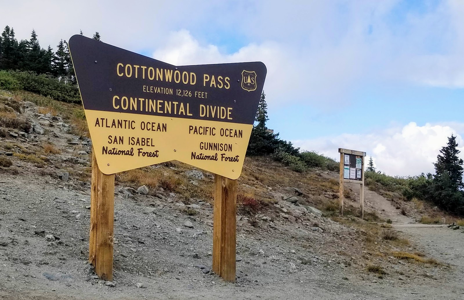
There is parking at the summit, trails, and a sign showing that we were traveling over the continental divide where water would feed on the eastern side to the Atlantic Ocean, and from the western side to the Pacific Ocean.


The summit vistas were magnificent!


We hiked for a while at the summit to enjoy the "top of the world" views and then continued our drive.


We continued driving on the western portion of Cottonwood Pass...


...and stopped again at Taylor Park Reservoir, at 9,500 feet elevation, to enjoy the view of the Sawatch Mountains in the distance.


We also stopped at the Taylor Park Dam to take photos.


Although autumn of 2019 was delayed by unusually warm weather, the colors here were brighter than in other areas.


The Taylor River was particularly pretty.


There were many ranches in this area around Almont,  Colorado, which was very evident by all the cattle we saw freely strolling around near the road...


...and even on the road!


They did not have a care in the world!


We finally reached Crested Butte.  I've blogged about this colorful ski town in the past--click here and hereOn this visit, it began to rain! We had lunch in town and continued on to travel back to Buena Vista but this time on Monarch Pass--my next post!


You can also find me on 


I'm linking this post to the following blog events:

 Mosaic Monday, All SeasonsBlue Monday, Through My Lens MondayLittle Cottage Link Party
 Hearth, and Soul Link PartyYou Are the Star Blog Hop, Inspire Me Monday,  Good Random FunNature NotesGrand SocialTravel Photos, Photo TunesHappiness Is HomemadeOver the Moon, Our World TuesdayRuby Tuesday, Tuesday Turn AboutTuesdays With A Twist, Let's Keep In TouchWordless Wednesday on a TuesdaySay Cheese!,  Party in Your PJ'sWordless WednesdayNanahood WWOh My Heartsie Girl's Wonderful Wednesday, Your Whims WednesdayWorldless  Wednesday My Corner of the WorldWonderful Wednesday Little Things ThursdayThankful ThursdayThursday Encouraging Hearts and HomeFull Plate ThursdayFriendship FridaysFriday Features Linky Party, Skywatch FridayFuntastic Friday,  Pink SaturdaySaturday Critters
 Grammys Grid-Month Long Linky Party


Bookmark and Share

Sunday, October 14, 2018

The Historic Town of Crested Butte, Part Two


My husband and I were away for a week on Long Island, New York, celebrating our anniversary and a special milestone anniversary of my oldest brother and sister-in-law. It was hot and humid while we were in New York and there were just the beginnings of autumn color. When we returned to Colorado autumn was happily still in full bloom and today we even added a little snow to the mix! I am continuing on this post with our early autumn trip to Crested Butte, Colorado. You can see its famous 12,168-foot (3,709 m) mountain, for which it is named, in the photo above.  (All photos and photo collages will enlarge if clicked on)


There was lots of beautiful autumn color and signs directing us as we approached the historic district in the town of Crested Butte. The park bench we passed in town made me smile--this indeed, was the place!


The East River Valley, where Crested Butte is located, was once used as a summer residence by the Ute people. However, they were quickly displaced when European-Americans first entered the area. The first white people to explore the valley were beaver trappers, shortly followed by surveyors. Captain John Gunnison, after whom Gunnison County is named, was one of the early explorers to enter the area. In the 1860s and 1870s coal and silver mines began to open in the surrounding area, and many little mining towns formed. However, when silver mining began to decline, many of these towns failed. Crested Butte, however, was in a better position to survive because it served as a supply town to the surrounding area. There were proposals in the early 1970's to open molybdenum mines on Mount Emmons (also known as the "Red Lady") near Crested Butte, but the town opted to continue to develop its ski industry instead. 


Crested Butte's Mountain Resort began in the 1960's and its popularity grew.  Hotels and resorts opened on Crested Butte Mountian. The annual snowfall average in the area is 198.4 inches (504 cm) with January recording the highest average snowfall at 40 inches (100 cm), so skiing and snowboarding are full winter activities.


The ski area base is at 9,375 feet (2,858 m). 14 lifts serve 1,058 acres (4.28 km2) of terrain. 448 acres (1.81 km2) of the terrain are double black diamond runs. A large amount of extreme skiing terrain at Crested Butte has attracted the US Extreme Skiing Championships. The longest run on Mount Crested Butte is 2.6 miles (4.2 km). The town of Crested Butte has a Nordic Center which has an ice skating rink as well as many miles of groomed cross-country skiing trails. Recently, Vail Resorts purchased Crested Butte Resorts.  I hope they will retain their nickname as "The Last Great Ski Town" even as part of this resort conglomerate!


When we visited Crested Butte on the first day of autumn, we were surprised and excited to see an annual "Vinotok Festival" in the town.  If you did not read my Crested Butte--Part One blog post--click here-- you may want to see what this fun bohemian Autumn Festival is all about!


The town of Crested Butte is a charming place.  Who wouldn't want to live in this cute little purple house seen in town?


I enjoyed walking around the town taking photos of the historical buildings. The town boasts fabulous restaurants, galleries, and shops


The Victorian era homes and businesses were colorful and well kept.


Real estate has become expensive as Crested Butte's popularity has grown. I was quite surprised at the prices of small houses such as these!

Crested Butte also has the nickname as "The Wildflower Capital of Colorado" as its surrounding mountains are filled with wildflowers in the late spring and summer, and there is an annual Wildflower Festival in July. It also hosts an annual Arts Festival. Film Festival and Music Festival.


Bicycling, camping, hiking, backpacking, rock climbing, whitewater rafting and kayaking, four wheeling, disc golf, horeseback riding and fishing are all popular summer activities.


The Crested Butte Mountain Heritage Museum, located at 331 Elk Ave is worth a visit to learn about the history of the town and area. It is housed in what was once a blacksmith's shop and then went on to be a hardware shop that had the first gasoline pump in town.


Ranching has also been a major industry in the surrounding Crested Butte area. We passed many a scenic ranch on our drives.


We also saw such amazing autumn foliage! 


One of the drives we made in the area was on the West Elk Loop Scenic Byway, over Kebler Pass, where there were the largest and highest aspen trees I ever saw and wonderful wilderness!  More about that on my next post.

To read part one of the Crested Butte, Vinotok Autumn Festival click here.


You can also find me on 


Bookmark and Share