Showing posts with label Ghost Towns. Show all posts

Monday, March 9, 2020

Ghost Towns of Vicksburg and Winfield, Colorado


In autumn of 2019, my husband and I took a scenic drive in Colorado into Clear Creek Canyon, between Buena Vista and Leadville, Colorado to visit the silver mine ghost towns of  Vicksburg and Winfield.


We took Highway 24 north from Buena Vista until we reached County Road 390/Clear Creek Reservoir.  CR 390 is an unpaved dirt/gravel road but it is easily traveled by a regular car or SUV.  The surrounding trees along the road and high up in the Sawatch Mountain Range had the beginnings of beautiful autumn color.


There were many beautiful mountain views along the drive.


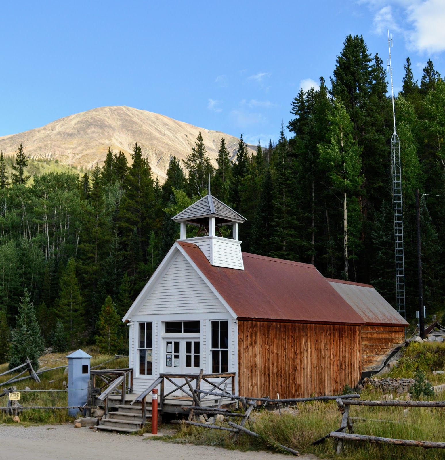
In about nine miles we reached the town of Vicksburg.
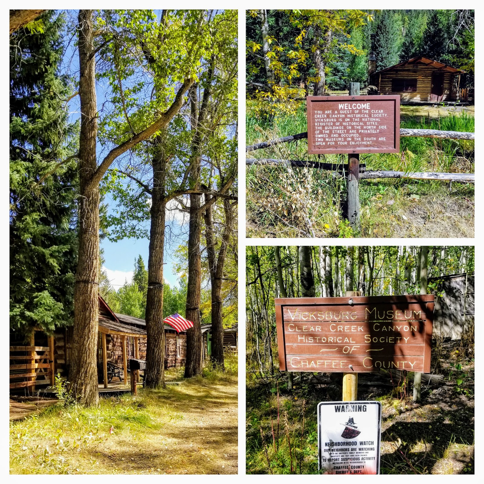


Vicksburg was founded in 1867 after prospectors from Leadville, Colorado, who were camping out in the Clear Creek Canyon lost their burros. The burros had wandered down the creek and when the miners found their pack animals, they discovered gold in the creek bed as well. More than gold, however, the surrounding area was rich in silver and copper. Early miners brought in "Balm of Gilead" (balsam poplar) trees on the backs of burros and planted them to line the main street of Vicksburg, where they still remain


Vicksburg was the second largest town in the canyon, with around 600-700 people during its peak. A museum is open here on some weekends during the summer, run by the Clear Creek Historical Society.  Many of the cabins in Vicksburg are now privately owned and seasonally occupied.


Quite a few interesting vintage mining implements and machines were on display around the cabins.


After visiting Vicksburg we continued on our drive...


...passing an area that obviously suffered an avalanche in winter at one time as many aspen trees lay broken on their sides along the side of the road.


Between Vickburg and Winfield is a small assortment of cabins for rent where more silver-boom towns once stood -- the towns of Rockdale and Silverdale. There are rustic cabins available for daily rent here. We spoke with a forest ranger who was sweeping out a cabin and she told us fishermen, hikers, mountain climbers, etc, rent the cabins all summer.


Continuing on for about five miles we reached the end of the county road and the town of Winfield.


Winfield was founded in 1861 with the first recorded silver prospecting done in 1867. Located on 120 acres at the junction of the north and south forks of Clear Creek, the town made lots of 50×100 free to anyone who desired to build there. In its prime, around 1890, some 1500 people lived in town. The silver market crash and depression in 1893 halted the mining activity in Clear Creek Canyon. There was a resumption in the early 1900s and the last ore was hauled out of the canyon by two-horse wagon in 1918.


Please click on photo to enlarge it


The history of the town is displayed in an open book in the Winfield schoolhouse window.


Two of the buildings are open as a museum during the summer, hosted by members of the Clear Creek Historical Society, while the rest are now privately owned and occupied seasonally.


There were quite a few trailheads located at the end of Winfield. The Winfield Cemetery was a quarter mile down a narrow winding road that would require high clearance 4WD.  Although 26 people are buried there, only two stone marker stones for children remained. In 2016, a descendant of one of the men buried there worked with the historical society to clean up the cemetery and place wooden crosses on the graves.  If you would like to see a local Denver news video about that effort and the story click here.


Can you imagine living such a rugged life at 10,000 feet, all because of hopes and dreams of finding riches in the surrounding mountains? The gold and the silver rush is the pioneer story of the state of Colorado and became the "boom and bust" of many a town.  To see more Colorado mining ghost towns visit my post on the Independence Pass Ghost Town--click here--and Saint Elmo Ghost Town--click here.


You can also find me on 


I'm linking this post to the following blog events:

 Mosaic Monday, All SeasonsBlue Monday, Through My Lens MondayLittle Cottage Link Party
 Hearth, and Soul Link PartyYou Are the Star Blog Hop, Inspire Me Monday,  Good Random FunNature NotesGrand SocialTravel Photos, Photo TunesHappiness Is HomemadeOver the Moon, Our World TuesdayRuby TuesdayTuesday Turn AboutTuesdays With A TwistLet's Keep In TouchWordless Wednesday on a TuesdaySay Cheese!,  Party in Your PJ'sWordless WednesdayNanahood WWOh My Heartsie Girl's Wonderful Wednesday, Your Whims WednesdayWorldless  Wednesday My Corner of the WorldWonderful Wednesday Little Things ThursdayThankful ThursdayThursday Encouraging Hearts and HomeFull Plate ThursdayFriendship FridaysFriday Features Linky Party, Skywatch Friday,   Pink SaturdaySaturday Critters
 Grammys Grid-Month Long Linky Party

Bookmark and Share

Sunday, February 9, 2020

St. Elmo Ghost Town


St. Elmo is one of the best-preserved ghost towns in Colorado.  Founded in 1880, St. Elmo lies in the heart of the Sawatch Range, 20 miles (32 km) southwest of Buena Vista and sits at an elevation of 9,961 feet (3,036 m). Nearly 2,000 people settled in this town when mining for gold and silver started in Chafee County.  There were 150 patented mine claims within the area.  The Mary Murphy Mine was the largest and most successful mine in the area and recovered multi-millions worth of gold while it was in operation.  St. Elmo was originally named Forest City but was later changed because of the multitude of towns with the same name. The name St. Elmo was chosen by Griffith Evans, one of the founding fathers, who was reading a novel with the same title


The town was at its peak in the 1890s when it included a telegraph office, general store, town hall, 5 hotels, saloons, dancing halls, a newspaper office, and a schoolhouse. The Denver, South Park and Pacific Railroad line ran through St. Elmo.  The train traveled on through the Alpine Tunnel, located nearby, which was once the highest railroad tunnel in the world, at an altitude of 11,523 feet.  It was the first tunnel to be built through the Continental Divide. Unfortunately, the line was plagued with accidents and storms during its 30-year life until, finally, the railroad company gave up on the dangerous and accident-prone tunnel. The last train came through in November 1910, which along with many mines becoming depleted and closing, created a major decline in the population of St Elmo. 


When my husband and I decided to visit the town of Buena Vista for our anniversary in October to enjoy the hot springs of Mt. Princeton in nearby Northrop, Colorado--click here--to read that post, I was also excited to add on a drive to see St Elmo.  I follow many Colorado photography groups on Facebook and have always been enticed by photos that I've seen of this town.


The Chalk Cliffs


The 15 mile Chalk Creek Drive--Chafee County Road 162--from Nathrop to St Elmo is paved in the beginning and turns into a well-graded dirt road for the last five miles. 


It was a scenic drive through the mountains, where the aspen trees were just beginning to turn their autumnal gold color.  We were surprised, as autumn color usually arrives in late September at the higher elevations in Colorado, but we had an unusually warm, dry summer which seemed to delay the change.


When we arrived at St Elmo one of the first buildings we saw was the General Store It is operated seasonally May through October, weather permitting, and sells souvenirs, antiques and snacks, cabin rentals, ATV and snowmobile rentals and tours, and a bed and breakfast.  We learned that all of St Elmo's buildings are owned by a private foundation that is, thankfully, concerned with stabilizing and preserving them. The community is listed on the National Register of Historic Places as the St. Elmo Historic District


The School House and Town Hall are both owned and operated as museums by Buena Vista Heritage, but neither was open on our visit.


Some of the antiques for sale next to the general store.


Once the mining industry shut down, St. Elmo drastically declined in population. Miners searched elsewhere for gold and silver and the business district in St. Elmo closed down as well. Few people continued to live in the town. It was said most of the population rode the last train out of town in 1922.


The last original residents that did remain in town were a sister and brother, Annabelle and Tony Stark, who lived in the house above. Their father and mother ran a hotel and general store and later the post office was located there. As the town deteriorated, so did their lifestyle and health, and they were removed for their safety when they were elderly, around 1958.  You can read more about them on this link.  

Please click on to enlarge

There was a poster with a brief history of St Elmo in one of the building's windows and I was able to zoom in on a photo of Annabelle feeding the chipmunks.


When I saw this sign in the town I smiled as I thought it was a cute joke...


...until multiple chipmunks ran out from beneath the piles of wood and began climbing on me, begging for a treat!   Obviously, Annabelle's chipmunk friends' descendants still live in St. Elmo and are a popular tourist attraction.


One of the seasonal cabins for rent in St Elmo.  Chalk Creek runs through the town and offers fishing opportunities, there are many hiking trails in the area and the old mining roads are now used for ATV and Jeep recreation.


We really enjoyed our visit to St Elmo--it was a step back into time, and I'm glad that efforts are being made to preserve it and its history.

We returned to Buena Vista for the night, with plans on driving over the newly reopened and refurbished Cottonwood Pass to Crested Butte the next day.  More about that wonderful adventure in my next post.

You can also find me on 


I'm linking this post to the following blog events:

 Mosaic Monday, All SeasonsBlue Monday, Through My Lens MondayLittle Cottage Link Party
 Hearth, and Soul Link PartyYou Are the Star Blog Hop, Inspire Me Monday,  Good Random FunNature NotesGrand SocialTravel Photos, Photo TunesHappiness Is HomemadeOver the Moon, Our World TuesdayRuby TuesdayTuesdays With A TwistWordless Wednesday on a TuesdaySay Cheese!,  Party in Your PJ'sWordless WednesdayNanahood WWOh My Heartsie Girl's Wonderful Wednesday, Your Whims WednesdayWorldless  Wednesday My Corner of the WorldWonderful Wednesday Little Things ThursdayThankful ThursdayThursday Encouraging Hearts and HomeFull Plate ThursdayFriendship FridaysFriday Features Linky Party, Skywatch FridayFuntastic Friday Pink SaturdaySaturday Critters
 Grammys Grid-Month Long Linky Party


Bookmark and Share

Monday, June 26, 2017

Independence Pass, Colorado, Part Two


Last week I blogged about the beginning of a drive my husband and I went on Highway 82 to cross over Independence Pass, which is the highest mountain pass in Colorado.  It is only open from the end of May through sometime in October as the rest of the year it is covered with heavy snow. Click here to read that post.  That post ended with our stop at the Independence town site--now a "ghost town" of abandoned and crumbling buildings, remnants from a once thriving gold rush site.


Independence Ghost Town is located 16 miles east of Aspen, Colorado, on Highway 82. There was a parking area off the highway, and then a hike down toward the town. You can see some standing buildings in the photos above as we approached the town.
Legend has it that the town of Independence was formed when prospectors discovered the Independence Gold Lode on July 4, 1879. A tent city sprang up that summer and by the next year there were 300 people living in the camp.


Placard on the site--click on it to enlarge.

By 1881 the Farwell Mining Company had acquired most of the mines in the area, as well as operated the Farwell Stamp Mill and a large sawmill for their mines. The population of Independence grew to 500 and was served by four grocery stores, four boarding houses, and three saloons. By 1882, the town had over 40 businesses with three post offices and an estimated population of 1,500 people!


Even though we were visiting at the end of the month of May, there were still areas of heavy snow all around the ghost town site. I could only imagine what the winters were like there, with many feet of snow for months on end from October to May, high winds, avalanches, hail, and cold. Those gold prospectors had to be a hardy bunch, desperate to strike it rich, in order to want to live here.


Placard at the site--click on it to enlarge

Most of the buildings were complete ruins with the exception of a few, yet it was interesting to hike around the site and read the informational placards and imagine life in that era.


This is considered to be the general store, one of the buildings in better condition...


...and this well-built miner's cabin still stands.


Life was harsh here at 10,900 feet and many miners were lured away from Independence to the milder climate of Aspen where they could also find abundant work and good pay.


Although mining at Independence proved to be short-lived, over $190,000 worth of gold was produced between 1881 and 1882.  The next year production fell to $2,000, and by 1888 only 100 people remained in the town.


In the winter of 1899, the worst storm in Colorado's history cut off the supply routes to Independence. The miners were running out of food so they dismantled their homes to make skis and escaped to Aspen.  It was the end of the town.


To learn more about Independence, and to support its preservation, visit the Aspen Historical Society.


After leaving the Independence Ghost Town we went back on our way on Highway 82 to travel over the pass.


We could see the road gaining elevation ahead...


...and we entered beautiful snowy landscapes as we traveled higher in elevation.


The view looking down at the Roaring Fork Valley was magnificent!


At last, we were at the very top of the pass! There was a parking area and a scenic overlook. The snow at the side of the road was higher than our heads!


We took a photo by the iconic Independence Continental Divide sign...


...and decided to walk to the overlook, as we saw others doing.


Unfortunately, we managed to walk into a snow drift and I began to sink into the snow. At first, I thought it was funny until both legs were stuck in snow up above my knees and I could not move!  My husband tried to help me out and then he also sank down into the snow. Two young men thankfully came over and helped us climb out. We were soaked up to our hips and decided that was the end of our walk.


Back in the car, we drove down the rest of Highway 82...


..to its end, in the small scenic community of Twin Lakes.  This area has beautiful views of the Sawatch Mountain Range, including the highest Rocky Mountain in Colorado, Mt Elbert, at 14,440 feet (4401 m)


We then drove onto US 24, and into the town of Leadville, at 10,152 feet, it is the highest incorporated town in the United States. In the late 19th century this silver mining town was the second highest in population in Colorado after the city of Denver. 


We only had time to drive through, but its historic charm could easily be appreciated and we know we will be back for a longer visit one day soon...


..as we'd also like to ride the scenic Leadville, Colorado, and Southern Railroad train!

From Leadville, we drove back to I 70 East and returned home.  It was a very full and exciting day. Colorado has many exciting and interesting places to see, and Independence Pass was definitely worth the trip!

Click here to read part one of our ride over Independence Pass.

You can also find me on


Bookmark and Share